|
Brace yourselves...4 near-identical panos are coming!
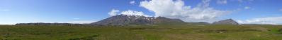
Sornfell is a beloved picnic-spot on The Faroes. It is a former, off limits, military facility, that has been opened for the public. It means that it is possible to drive nearly to the summit, making it the obvious drive-in fjeld. Since it is a one-track road, with few passing points, it is risky business driving on a sunny evening.
I went for a late evening trip with my son, but I was disappointed to find out that the dew point was below the summit, and so chose to make as many panos for the trip up, before standing in the clouds. I therefore will show four panos from various heights, and starts with this one. It was the first really good overview point, and made as a security if it became all fog and clouds later on. On the Faroes, you quickly learn, that this can happen very quickly. Unfortunately, I left my 50mm lens at the hotel, so I had to use the 70-200mm zoom. Also, unfortunately, the view to the southern islands Sandoy and Suðuroy was completely obscured by fog, but apart from that, it was acceptable conditions :-)
Pano made from 25 pics (RAW), 70-200mm@70mm, iso-160, f/9, 1/320 sec, developed in DPP (cloudy, neutral, moderate sharpness), stitched in PTGui pro, scaling and sharpening in Irfanview.
PS: The horizon may seem dodgy to the SE, but it is a fog bank over the sea that gives the impression of a slight tilted horizon.
Alvise Bonaldo, Hans-Jörg Bäuerle, Günter Diez, Friedemann Dittrich, Johannes Ha, Leonhard Huber, Heinz Höra, Johann Ilmberger, Martin Kraus, Dieter Leimkötter, Giuseppe Marzulli, Steffen Minack, Niels Müller-Warmuth, Jörg Nitz, Danko Rihter, Arne Rönsch, Björn Sothmann, Arjan Veldhuis, Jens Vischer, Benjamin Vogel
|
 |


Kommentare
Cheers, Hans-Jörg
But to me it's not the mountains and not even the sun, but the water in the middle part, that catches my eyes.
Splendid pano!
Kommentar schreiben