Kornati   62586
vorheriges Panorama
nächstes Panorama
Himmelsrichtungen ein / ausHimmelsrichtungen ein / aus
Details / LegendeDetails / Legende Marker ein / ausMarker ein / aus Übersicht ein / ausÜbersicht ein / aus   
 Durchlauf:   zum ersten Punkt zum vorherigen Punkt Durchlauf abbrechen
Durchlauf starten
Durchlauf anhalten
zum nächsten Punkt zum letzten Punkt
  verkleinern
 

Legende

1 P. 266 m, 18 km
2 Otok Ugljan
3 Otocic Karantunic, 8 km
4 Zdrelac bridge, 10 km
5 Zadar, 18 km
6 Zdrelac
7 VELEBIT
8 Sveto Brdo 1751 m, 52 km
9 P. 259 m, 9 km
10 Cetinarica 1404 m, 61 km
11 Otok Pašman 257 m, 16 km
12 Otocic Balabra Vela, 4 km
13 Otocic Bozikovac
14 P. 1136 m, 76 km
15 Otok Sit, 6 km
16 Otocic Brusnjak, 5 km
17 Otocic Kurba Mala
18 Otok Scitna, 9 km
19 P. 248 m, 42 km
20 Otok Arta Vela, 26 km
21 P. 491 m, 64 km
22 Otok Kosara, 16 km
23 Otok Vrgada, 23 km
24 Murter, 34 km
25 P. 378 m, 71 km
26 Otok Kakan, 43 km
27 Otocic Tetoviusnjak Veli, 38 km
28 Otok Zut, 9 km
29 Otocic Glamoc, 4 km
30 Otocic Lavdara Mala, 2 km
31 Otocic Brskvenjak, 5 km
32 P. 220 m, 12 km
33 Otok Kornat
34 Otok Katina, 5 km
35 Dugi Otok
36 Sali
37 P. 318 m, 14 km
38 Otok Rava, 14 km

Details

Aufnahmestandort: Otocic Lavdara (60 m)      Fotografiert von: Jan Lindgaard Rasmussen
Gebiet: Croatia      Datum: 2017-07-06, 13:46
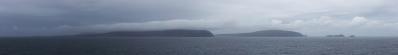
One of our days was spent on a boat trip to the Kornati NP archipelago, cruising around between the islands. It was hot and burning, so a fine day to go on the water. We spend appr. 4 hours on the island of Lavdara; here we went swimming, had lunch, and a very hectic gipfelsturm for me. I only had 30 minutes to sprint upwards, so this viewpoint was chosen. While up here, the boat sounded its horn, so I didn't have time for the next top. Anyway, it gave a very nice overview of the whole archipelagic landscape, though the air had become slightly less clear compared to our first 2 days. These islands offers a gigantic fernsicht to Gran Sasso in Italy, at a modest elevation of +100 meters, and free horizon to the west. Something to aim for next time!

Pano made from 21 pics (RAW), Canon 6D, 50 mm, 1/500 sek, f/9, iso-100, developed in DPP (daylight, neutral, moderate sharpness), stitched in PTGui pro, contrast in GIMP, downscaling and sharpening in Irfanview.

Kommentare

Very nice pano, Jan and again I like the colors very much! Below 149, I notice an unusual white spot on the mountain, which should be a white rock I guess?
02.10.2017 20:02 , Mentor Depret
Yes, it looks odd, It seems (if you visit Google Earth) there has been a violent landslide, exposing the bare chalk rock underneath. Below there are clearly brighter soil, although overgrowing. It seems there is a slate structure, and the upper layer simply slided off. LG Jan.
02.10.2017 20:57 , Jan Lindgaard Rasmussen
Sehr schöner und informativer Rundblick über diese Insellandschaft.
03.10.2017 05:55 , Friedemann Dittrich
This view was well worth the sprint. Cheers, Martin
03.10.2017 10:11 , Martin Kraus
"...advantage Rasmussen ..." - a person who creates daily panoramas in Denmark, also feels "poodle well" :-)) on the Croatian coastline - impressive composition, very well done, dear Jan !!

Cheers, Hans-Jörg
03.10.2017 12:38 , Hans-Jörg Bäuerle
Obviously less flat than the Danish island world, but nevertheless interesting.
03.10.2017 18:26 , Jörg Braukmann

Kommentar schreiben


Jan Lindgaard Rasmussen

Portfolio

Weitere Panoramen

... in der Umgebung  

Žut - West (7km)

9

Žut - Ost (7km)

8
... aus den Top 100