Take a look, and give a comment...   143783
previous panorama
next panorama
Details / LabelsDetails / Labels Markers on / offMarkers on / off Overview on / offOverview on / off   
 Cycle through labels:   first previous stop
play
pause
next last
  zoom out
 

Labels

1 Troldemose Bakke 110 m + trees, 91 km, or unknown fata morgana.
2 Poss. blur from Endelave island 5 m + trees, 68 km.
3 Elmebjerg 41 m, Nekselø island, 7 km.
4 Lushage, Samsø island, 48 km.
5 Tele tower Søsterhøj, Jutland, 81 km, original size.
6 Original size crop of the fata morgana.

Details

Location: Vejrhøj. (121 m)      by: Jan Lindgaard Rasmussen
Area: Denmark      Date: 2012-03-25, 13:33.
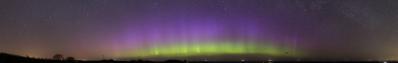
...if you have an opinion. I think the slightly uneven line in the horizon, to the left of Samsø, shows Troldemose Bakke, 110m + trees. It is located between Vejle and Horsens in Jutland, more accurately between Juelsminde and Horsens. At a distance of 91 km it is the farthest view (so far) in Denmark. I would really like the opinion of the experts here.

The direct view stretches over the nearby island Nekselø (7 km), then just south of Samsø island (49 km), and then over Endelave island (68 km). Endelave island is however very low, but wooded, so a possible max. height for Endelave could be 20 m trees + 5 m üNN = 25 m.

The distance to the horizon can be calculated: distance (km) = Vheight (m) x 3,86, with refraction taken into account. The horison from my pov (121m + 1,90m) = 42,8 km. Endelave horison (25m) = 19,3 km. All in all that gives a possible view distance of 62 km. As the distance is 68 km, Endelave should not be in the way. When I look on the pics in 100%, there is a slight blur on the horison, so perhaps the treetops just can make it over. Troldemose Bakke is also forested, so with 20 m trees + 110 m üNN = 44 km. Added to the possible horison from here, 44 km + 42,8 = 86,8 km. With the distance being 91 km, it seems the refraction was in a particular good mood that day - if it was in fact Troldemose Bakke I saw.

The pano is cropped pretty tight, and will be reloaded or deleted, depending on the opinions. Right now it is shown with maximum attention to the horison.

Pano made from 2 pics, 300 mm, iso-100, f/10, 1/640s. Stitched with Hugin, auto adjusted colours, scale and sharpening in IrfanView.

Comments

really really interesting! greetings Seb
2012/04/10 17:12 , Sebastian Becher
Hallo Jan, ich wollte mich mit Deinem Bild beschäftigen, bin aber über Deine Formel gestolpert. Diese solltest Du erst verbessern, denn das "Vheight" soll doch bestimmt "Wurzel aus height" heißen. Beim Überprüfen der Formel bin ich dann - wie das so ist - auf andere interessante Seiten gestoßen, so daß ich jetzt erst mal keine Zeit für Dein Bild mehr habe und hoffe, daß ich mich heute abend nochmal damit beschäftigen kann.
2012/04/11 13:37 , Heinz Höra
Hello Heinz. Genau, it shall be the square root - I just don't know how to put that symbol on, therefor I used the V as symbol. Sorry for the confusion. Also in kurz: Would you consider this to be a valid documented observation? LG Jan.
2012/04/11 17:08 , Jan Lindgaard Rasmussen
Jan, ich bin gerade dabei, es zu prüfen. Die Projektion, die Ulrich Deuschle aus den SRTM-Höhendaten erzeugt, zeigt für den Vejrhoej im Winkelbereich 261° bis 271°, also +/- 5° um die Südspitze von Samsoe, als weitestes sichtbares Land nur die Insel Samsoe in ca. 55 km Entfernung. Links davon ist nur der Meereshorizont in ca. 43 km Entfernung, also nichts von Endelave und auch nichts von Troldemose Bakke zu sehen.
Ich habe mich in letzter Zeit bei meinen Rügen-Recherchen mehrmals überzeugt, daß Ulrich Deuschle mit seinen Tool auch für solche See-Land-Gebiete genaue Abbildungen erzeugt. Dafür, daß er das so gut realisiert hat, muß ich ihm noch meinen Dank aussprechen.
Zusätzlich habe ich die Höhenwinkel mit normaler Refraktion, ausgehend vom Vejrhoej 121+2m berechnet: Der Sichthorizont in 42,3 km erscheint unter -0,33°, Samsoe - Lushage mit 10m in 50km ergibt -0,32° = sichtbar, Troldemose Bakke 110m + Bäume 20m in 91km ergibt -0,35° = nicht sichtbar, liegt unterm Meereshorizont.
Troldemose Bakke wird im Tool von UDeuschle erst sichtbar, wenn die Kamerahöhe größer 75 m ist. Mit dieser Höhe über dem Vejrhoej errechne ich auch Höhenwinkel, die positiver als die des Meereshorizontes sind.
Das zeigt aber, daß man mit der von Dir benutzten Näherungsformel für den Sichtkreiradius zwar qualitative Aussagen machen kann, aber im Grenzfall ist die Aussage so la-la, selbst wenn man mit veränderten Koeffizienten rechnen würde.
Das waren bisher Berechnungen für den Fall mit normaler Refraktion. das scheint aber bei Deiner Aufnahme nicht so gewesen zu sein. Besonders der rechte Teil sieht ja aus wie eine Fata Morgana. Und das müßte geklärt werden, woher diese Überhöhung kommt. Mich wundert aber, daß diese Fata Morgana nicht auf den 1 Minute später gemachten Panorama # 9923 zu sehen ist.
2012/04/11 19:09 , Heinz Höra
Thank you so far, Heinz... 
...I believe that you have made a valid explanation, that a 91 km view isn't possible. What is to be seen has to be solved. I have some further information to the pano + a reload, but I need to get over to my usual computer. I'll be back! LG Jan.
2012/04/11 21:00 , Jan Lindgaard Rasmussen
To my mind the distortions may be due to the enormous difference between the water temperature of 3 - 4°C at that time and the warm air above. LG Wilfried
2012/04/12 09:43 , Wilfried Malz
Reload. 
To make a short story long: When I made some panos from Røsnæs on 2011-12-18, I regretted not to have made a 300 mm zoom from the part Æbelø to Samsø. 2012-03-03 I was out there again in the afternoon, but in a much paler and brighter lightsituation. I made some panos, but we'll see about them...This part, added, now has a purpose. The "Gestalt" of Troldemose Bakke can be made out quite clear, though the angle is a bit different from Vejrhøj. As an obvious feature one can see, that it has a tele tower, and I wonder if one could see that on 91 km. I guess one should. The tele tower on Søsterhøj (81 km) is the same type, except that a very high and thin antenna has been put on top. If not obvious on the actual pano, then on the original pics. I have added the full-size parts with the tower and the fata morgana. LG Jan.
2012/04/12 17:22 , Jan Lindgaard Rasmussen
Hello Wilfried and Heinz. The fata-morgana could perhaps be caused by the more nearby island Endelave? The angle fits for that island. Like Heinz said, one can wonder why there is fata-morgana here, and not further north on the other pano. Like I explanained there it looked as if the sea-fog lifted over Kattegat that day, but was still present further south.

Last chance to comment, goes out in a few days. Thank you for helping. LG Jan.
2012/04/13 16:20 , Jan Lindgaard Rasmussen
Warum willst Du es hinauswerfen, Jan? Gut Ding will Weile haben. Ich arbeite an einer weiteren Antwort. Du hast doch ein ganz neues Feld eröffnet.
Außerdem solltest Du bedenken, daß dann mein Kommentar, der eine Menge Arbeit bereitet hat, verschwindet.
2012/04/13 17:52 , Heinz Höra
Hello again, Heinz. Yes, sorry. It doesn't hurt to keep it, of course. I just thought it was something exciting turning a little dull. And the reload has become somewhat messy - what it relevant, and what is not? LG Jan.
2012/04/13 19:37 , Jan Lindgaard Rasmussen
Jan, wahrscheinlich wäre es besser, wenn Du die Erweiterung mit derm Roesnaes-Bild herausnehmen würdest und diese extra bringen würdest. Dann könnte man hier ohne Ablenkung über die Ursachen dieser "Fata-Morgana"-Überhöhung diskuttieren und Deine weitere ausgezeichnete Roesnaes-Fernsicht könnte man dann gesondert würdigen.
2012/04/13 22:34 , Heinz Höra
OK Heinz.

By the way: Ææ = Ää, und Øø = Öö. The letters are scandinavian, but they are pronounced as shown, equal to german. Røsnæs = Rösnäs, und Møn = Mön (rhymes on schön).

Will try another reload soon. LG Jan.
2012/04/13 22:49 , Jan Lindgaard Rasmussen
Gut, Jan, dann werde ich Røsnæs im Speicher vorhalten, um das ø und das æ immer bereit zu haben.
Was bedeutet eigentlich der Name Vejrhøj?
2012/04/13 23:20 , Heinz Höra
Hello again. Is this better?

Vejr-høj (pronounced Wär-hoi) means Wetter-hoch. A hill that apparently is able to influence the weather. And you may not believe it, but it is true, just not on the large scale as Brocken or other mittelgebirge. Most weather in Denmark is sw-nw incoming fronts from cyclogenesis - moving low pressures. Therefor just slightly uneven and rising reliefs can cause rain. South-western Jutland receives 823 mm of rain/year, western Sjælland only 584 mm/year. However, in Jutland, the coastal area can be just as dry as the Great Belt area. LG Jan.
2012/04/14 09:21 , Jan Lindgaard Rasmussen

Leave a comment


Jan Lindgaard Rasmussen

Portfolio

More panoramas

... in the top 100