|
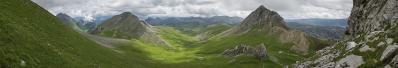
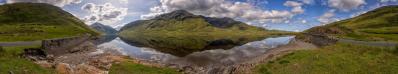
Nach den vielen Landschaften und Gipfeln muss ich aus den nordspanischen Bergen auch mal ein Dorf zeigen. Die Babia ist eine Hochebene auf etwa 1200m direkt südlich des Hauptkamms der Cordillera Cantábrica. Nach Südosten wird sie durch die Luna begrenzt - hier dominiert ein großer Stausee das Tal. Im Dorf San Emiliano fand sich ein netter Gasthof, in dem ich zwei Nächte blieb. Nach Ankunft lockte ein Weg auf einen Fels in der Dorfmitte. Die vielen Störche auf dem Nachbarfelsen kommen hier nur bedingt raus. Mein Tele war aber im Hotel, und später war die Sonne wieder weg.
After all the landscapes and peaks, I have to show a village from the mountains of northern Spain. The Babia is a high plateau at about 1200m directly south of the main ridge of the Cordillera Cantábrica. It is bordered to the southeast by the Luna River - here a large reservoir dominates the valley. In the village of San Emiliano I found a nice inn where I stayed for two nights. Upon arrival, a path on a rock in the centre of the village was tempting. The many storks on the neighbouring rock only appear here to a limited extent. But my tele was in the hotel, and later the sun was gone again.
Olympus OM-D E-M5 III
M.Zuiko 12-45/4.0 Pro @16mm (=32mm KB)
17 HF RAW freihand, ISO 200, 1/500, f8
Lightroom Classic CC, Autopano Giga 4.4.2, IrfanView
Direktlink auf Google Maps: https://maps.app.goo.gl/M8dJGc6sfaAYVvA67
Peter Brandt, Jörg Braukmann, Klaus Brückner, Hans-Jörg Bäuerle, Günter Diez, Jochen Haude, Dieter Leimkötter, Giuseppe Marzulli, Matthias Matthey, Jörg Nitz, Danko Rihter, Arne Rönsch, Björn Sothmann, Arjan Veldhuis, Jens Vischer, Benjamin Vogel
|
 |


Comments
LG Jörg
Grüße,
Dieter
Herzliche Grüße
Hans-Jörg
Leave a comment