|
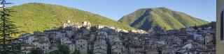
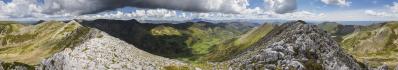
Die Serie von der nächsten Wanderung in Spanien beginne ich wieder mit einem Landschaftseindruck vom Aufstieg. Nach kurzer Anfahrt konnte ich in Abelgas de Luna gut am Ortseingang parken. Das noch nicht verlassene und lebendige Dorf ist spektakulär von Felsrippen umgeben - ich empfehle den Blick auf Google Earth, da ich das nicht im Panorama einfangen konnte. Meine Route führte mich erst sonnig und grün auf einem Fahrweg in das hier gezeigte, etwas südliche, nach Westen führende Tal. Nach Ende des Fahrwegs finden sich ein paar Wegspuren (wie hier links), schnell wird es aber weglos, und mein GPS Track leistete mir gute Dienste.
I'll start the series of my next hike in Spain again with an impression of the landscape from the ascent. After a short drive, I was able to park in Abelgas de Luna at the entrance to the village. The village, which is not yet deserted and is still alive, is spectacularly surrounded by rocky ridges - I recommend looking at Google Earth, as I was not able to capture this in a panorama. My route first took me up a sunny and green track into the valley shown here, which leads slightly south and then west. After the end of the road, there are a few trail tracks (like the one on the left here), but it soon becomes pathless, and my GPS track served me well.
Olympus OM-D E-M5 III
M.Zuiko 12-45/4.0 Pro @15mm (=30mm KB)
14 HF RAW freihand, ISO 200, 1/640, f8
Lightroom Classic CC, Autopano Giga 4.4.2, IrfanView
Direktlink auf Google Maps: https://goo.gl/maps/dvcbYc4UKk4AKFup8
Hans-Jürgen Bayer, Peter Brandt, Jörg Braukmann, Klaus Brückner, Hans-Jörg Bäuerle, Günter Diez, Claudia Gönner, Dieter Leimkötter, Giuseppe Marzulli, Matthias Matthey, Jörg Nitz, Danko Rihter, Silas S, Björn Sothmann, Konrad Sus, Arjan Veldhuis, Jens Vischer, Benjamin Vogel
|
 |


Comments
LG Jörg
Herzliche Grüße
Hans-Jörg
Grüße,
Dieter
Leave a comment