|
A few days camping at our family's favourite Provincial Park didn't exactly play out as hoped. The first day we had fairly thick smog from distant forest fires, the following days lots of rain. Still the ban on making campfires was maintained. Finally we decided the go back home after just two nights. Well, we still had a substantial job cleaning and drying and properly packing our equipment once back home.
Luckily there were a few brighter moments.
My Oly camera gear might be feeling I don't like it any more because I don't remember using it for any landscape or panoramic pictures this year. But I don't blame the Oly.
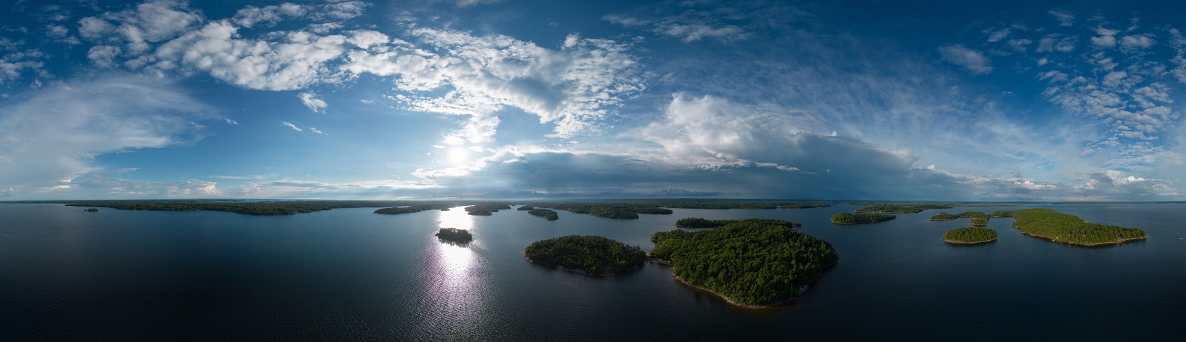
This is a cylindral 360 degree excerpt from a spherical (Kugel) panorama captured with the DJI 3 mini pro drone.
The pano was taken at the max allowed altitude of 120m above ground, approximately 2km from the shore at Killbear Provincial Park. During the flight I captured 3 spherical panos (there's a preset for that) and when the drone returned I had used about half the battery charge. I realize the light conditions were fairly 'extreme' for the drone's little camera. Probably I should have captured additional individual shots of the backlit area into to the sun. Still I didn't feel too adventurous, because I had only once before flown the drone such a distance and felt a bit of anxiety.
Killbear or Parry Sound are at the Northern End of a region called 30'000 Islands. They are located in Georgian Bay, itself a part of Lake Huron.
I know that a few of the most prolific and respected members of this forum have reservations about the use of drones. Having taken lots and lots pictures and panoramas (on the ground) in this region before, the drone allowed me to see and capture a side that I hadn't seen before like this.
Sphere stitched from 35 individual pics raw, full resolution approximately 160 megapixel (preprocessed in Lightroom, stitched using PTGui):
https://www.360cities.net/image/bright-afternoon-sun-on-an-otherwise-cloudy-on-the-30000-islands-canada
Alvise Bonaldo, Peter Brandt, Hans-Jörg Bäuerle, Günter Diez, Christian Hönig, Heinz Höra, Martin Kraus, Dieter Leimkötter, Giuseppe Marzulli, Danko Rihter, Arne Rönsch, Björn Sothmann, Konrad Sus, Arjan Veldhuis, Jens Vischer
|
 |


Kommentare
Ciao, Alvise
Die Tiefen sind mir ein wenig zu dominant. Der Grundcharakter ist vom Licht geprägt, das kommt mir hier etwas zu kurz. Ansonsten wäre das ein Bild, das sehr gut auf Acryl gedruckt an der Wand macht.
Grüße,
Dieter
Kommentar schreiben