
| Cycle through labels: |
|
| Femø, 45 km |
| Ørslev Kirke, 17 km |
| Femø, 45 km |
| Lilleø, 52 km |
| Fårdrup Kirke, 6 km |
| Eggeslevmagle Kirke, 9 km |
| Gerlev Kirke, 2 km |
| Fejø, 48 km |
| Vejrø, 38 km |
| Smålandshavet |
| Vejrø, 38 km |
| Kragenæs, Lolland, 50 km |
| Magleby Kirke, 15 |
| Lolland, 48 km |
| Lolland, 52 km |
| Stigsnæsværket, 19 km |
| Lolland, 55 km |
| Agersø, 22 km |
| Omø, 26 km |
| Boeslunde Kirke, 9 km |
| Agersø, 19 km |
| Langeland, 55 km |
| Egholm, 17 km |
| Hemmeshøj Kirke, 4 km |
| Frankeklit (Langeland), 35 km |
| Thurø, 54 km |
| Fyn, 50 km |
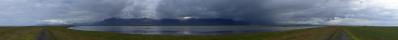
When looking at a map of Sjælland, it can be noted that there is a sharp southwestern corner on the island, between the cities Korsør and Næstved. It is this direction the panorama covers. In the southern direction, the view goes across the water to Femø. In the southwest, the defunct powerplant Stignæsværket, and the islands of Langeland, Agersø, and Omø can be seen.
Pano made from 44 pics (RAW), 300 mm, iso-400, f/7,1, 1/640 sec, developed in DPP (daylight, neutral, moderate sharpness, ALO off), stitched in PTGui pro, scaling and sharpening in Irfanview. |
||||||||||||||||
|
|||||||


Comments
Leave a comment