|
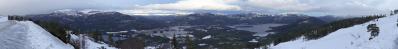
Again a pano from the Dronning Alexandrines Bridge, when it was possible to outmask it, and from the same day as #29167. This time it was done just after the sunset, and the had day turned out to be wonderfully clear. The view stretches from Stevns peninsula in the north, via the straits and islets, to the main islands of Møn and Falster. 2 upcoming telepanos will give a detailed view in either direction.
Pano made from 20 pics (RAW), 50 mm, iso-500, f/5, 1/200 sec, developed in Canon DPP (cloudy, neutral, moderate sharpness), stitched in PTGui pro, scale and sharpness in Irfanview.
Jörg Braukmann, Klaus Brückner, Hans-Jörg Bäuerle, Friedemann Dittrich, Heinz Höra, Martin Kraus, Stefan Lux, Wilfried Malz, Giuseppe Marzulli, Steffen Minack, Jörg Nitz, Danko Rihter, Arne Rönsch, Silas S, Björn Sothmann, Jens Vischer, Benjamin Vogel
|
 |


Comments
Nachdem ich mir dann Bilder von dieser schönen Brücke bei Google Maps angeschaut hatte und bei Wikipedia gelesen hatte, wie es 1943 während der deutschen Besatzung zu ihrem Bau kam, kam ich mir erst etwas übertölpelt vor.
The outmasking was possible because I could lean out over the sides, giving overlaps. Normally the sides are higher fenced, and crossing the bridgeroad is prohibited, but thanks to the repairs, this was a period of partly stripped elements. The concrete had been changed in two steps; first one side of the road, then the next side. Then also some concrete repairs of the underside, and also refitting and reinforcing some steel elements. This was done over a very long period; some times the bridge was closed, most of the time only one lane was in use. Mainwork done 2012-2016, and shorter repairs 2017-2018.
Like this for a long time: https://sn.dk/Vordingborg/Moenbroen-atter-ramt-af-vejarbejde-i-to-uger/artikel/746582
Doing this: https://mth.dk/Vores-Projekter/Moenbroen
On this day it was closed, but I parked on the Sjælland side, and sneaked/walked up early morning and late evening. All the sheds and signposts etc had been removed, so the outmasking became very clean. I only had to mask the road itself.
LG Jörg
Leave a comment