|
The first half of the pano shows the valley which is followed in the classical Santa Cruz trek, with start at Yanama or Vaqueria, both on the road to Paso Llanganuco. The high point is at Punta Union, followed by a long descent to Cashapampa.
I was coming the opposite way, namely, from Cashapampa, a solution which is avoided by those who like more the descent than the ascent. I had to return to the bicycle at Pomabamba, which lies noticeably north of Yanama. The solution was to cross the Alto de Pucaraju into the high Lucma valley. Pomabamba is then reached either crossing Tupatupa (4360) or, better, via the ruins of Yayno (N. 26108).
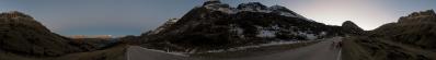
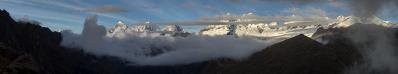
Instead of descending to the (relative) comforts of Quisuar, I camped on the pass, such to enjoy both sunset and sunrise. This is why I have a rather long and varied series of pictures from the Alto de Pucaraju, compensating the bad weather that I had in Punta Unión.
http://bit.ly/2M0y8LA
Location: -8.91537 -77.55526
Alvise Bonaldo, Klaus Brückner, Hans-Jörg Bäuerle, Günter Diez, Friedemann Dittrich, Klaus Föhl, Johannes Ha, Heinz Höra, Martin Kraus, Wilfried Malz, Giuseppe Marzulli, Steffen Minack, Jan Lindgaard Rasmussen, Danko Rihter, Arne Rönsch, Walter Schmidt, Björn Sothmann, Michael Strasser, Konrad Sus, Arjan Veldhuis, Jens Vischer, Alexander Von Mackensen, Augustin Werner
|
 |


Comments
Fosco Maraini approverebbe, anche se non sta dalle sue parti.
Greetings, Arjan
Leave a comment