|
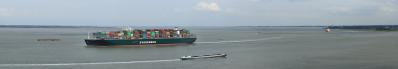
On one of the hottest days this year, I decided to bike to Breskens. I am on the dike right next to a fairly recently (2005) created new piece of nature, along an ancient creek, called Plaskreek (between 152°-241° on the pano). The Plas-creek itself is behind the trees although one can see a little bit of water against the dike. The pond, with an abundance of water birds, is recently excavated. The water is brackish and this almost guarantees a comeback of a wide variety of fauna and flora (with orchids!).
Although the mouth of the river Scheldt and the North Sea is just 13 km from here, one cannot see much of it, certainly at low tide, because the biggest and highest plate of the estuary: the Hooge Platen (18 km2 at low tide, up to + 6.9 m NAP), is in between. The highest points are the result of a dune belt that has formed on the plate (295.5°-300°).
Low tide level at the moment is average at about -1.5 m NAP.
On the other side of the river is the city of Vlissingen and Vlissingen Harbor with the nuclear powerplant of Borssele right in front of us.
Terneuzen city is mainly behind the Dow factory although Waterfront clearly sticks out.
I photographed a 360° but omitted the radar because I lost the top after stitching.
Canon Eos M6 with EF-M 18-150 mm, 33 p RAW, 50 mm (80 mm KB), iso 160, f 11, 1/320, tripod, PTGuiPro, 83553x3733 1.26GB TIFF, no crop, downsizing>1900>1000>500 TIFF>sharpening>11270x500 2.5MB JPEG
Jörg Braukmann, Hans-Jörg Bäuerle, Friedemann Dittrich, Walter Huber, Heinz Höra, Martin Kraus, Wilfried Malz, Giuseppe Marzulli, Steffen Minack, Jörg Nitz, Jan Lindgaard Rasmussen, Danko Rihter, Werner Schelberger, Björn Sothmann, Matthias Stoffels, Markus Ulmer, Jens Vischer
|
 |


Comments
Leave a comment