|
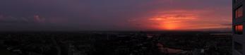
This very clear 240 mm KB tele view completes my documentation of the mouth of the river Scheldt and the skyline of the city of Vlissingen as seen from Terneuzen.
I can cut off the Dow factory to make the pano more appealing to the audience but I won't do that because it is the part I cannot photograph from the Waterfront building. Moreover, I consider it in some way 'a piece of art'. You will discover that within a few weeks.
Tide on the pano is average at about 0 m NAP. The lower plates are inundated. While part of the Hooge Platen is still visible in the middle, the highest levels (up to + 6.9 m NAP) near Breskens are largely hidden from view because of a mirage. This is also the case with the North Sea horizon left of Vlissingen.
Since 1999, the Vlissingen skyline is dominated by the 85 m high Sardijn tower which is the second tallest building of Zeeland after the 90.5 m Abbey tower Lange Jan of Middelburg (right in the pano) and apart from some industrial constructions in the harbor as well as the 137 m communication tower in Goes. In 2010, a 17 floors oval apartment building, called Hooglicht, was added to the scene. Just right of Hooglicht, one can distinguish the 54 m high dune near Zoutelande, which is often the highest but currently the second highest dune in the Netherlands. Anyway it is the highest hill in a 50 km radius (see pano 18039 on the top).
http://www.bouwregister.nl/nl/projecten/project/hooglicht-vlissingen/301/
Canon Eos M6 with EF-M 18-150 mm, 15 p RAW, 150 mm (240 mm KB), iso 200, f 11, 1/100 s, PTGuiPro, 39242x3742 591.9 MB TIFF, cropped to h=3226, downsized>1800>1000>500 TIFF>sharpening>6083x500 1MB JPEG
Hans-Jürgen Bayer, Jörg Braukmann, Klaus Brückner, Hans-Jörg Bäuerle, Friedemann Dittrich, Johannes Ha, Leonhard Huber, Walter Huber, Heinz Höra, Franz Kerscher, Martin Kraus, Giuseppe Marzulli, Steffen Minack, Jan Lindgaard Rasmussen, Danko Rihter, Björn Sothmann, Matthias Stoffels, Jens Vischer
|
 |


Comments
And I also read the information in the description with great interest.
Cheers, Hans-Jörg
Leave a comment