|
This would fit more naturally by the end of a series from this location, at least until after an overview had been presented - I just couldn't resist putting it on as a riddle.
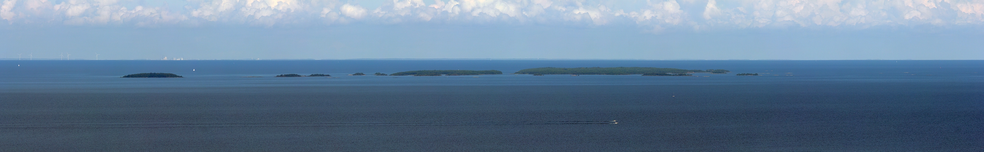
The relevance of the pano isn't the small archipelago, although it constitutes a national park, and also gives a certain depth and variety to the pano. The relevance is because it includes the farthest possible view from Kinnekulle. Theoretically, according to udeuschle, one can see 130 km from the tower, when 19 m is added as camerahöhe. But even in a strong zoomversion on udeuschle I cannot seperate the ridge of 130 km distance, from the ridge of 75 km. Also in the fullsize-pano, in the same part, I cannot see an extra ridge. I have marked the place in the pano. However, to the right of the holms, 2 weak appearences are beyond any doubt from a distance of 117 km. We look toward the city of Karlstad, and the landscape behind is part of Värmland, quite close to Johann Ilmbergers panos from this summer.
From the tower, it was obvious we had a clear day, with the whole lake clearly visible. But also nice, that it can be documented in this micro-like way :-)
See a little of the holms here:
http://sverigesnationalparker.se/en/choose-park---list/djuro-national-park/
The original riddle:
Let's see if anyone cracks this...from my latest holiday, I suddenly found myself looking at these holms. The islands portrayed seem insignificant, and perhaps they are, but they have their own wiki-page, even in english and german. The building behind isn't that special neither, but is an important landmark, that will verify a correct guess. I have used my 300 mm with a 1,4 extender, so all in all I am sporting a 420 mm lens. Orientation is added. You are allowed to fish for answers...I would like to know where I am and what I am looking at - have fun :-)
Pano made from 7 LF (RAW), 300 m + 1,4 extender = 420 mm, f/7,1, 1/1000 sec, iso-100, handheld, developed in DPP (cloudy, neutral, ALO off, moderate sharpness), stitched in PTGui pro, contrast boosted, downscaled and sharpened in Irfanview.
|
 |


Kommentare
A little hint: I would NEVER send the community on an endless search in the Baltic or Atlantic Schärengarten :-) Therefore, try to look for a, sort of, limited or isolated portion of Schären - perhaps neither Baltic nor Atlantic...Oh dear, I hope I didn't say to much. The buildings behind are indeed part of a massive industrial site.
Vielleicht ist es von Lolland aus gemacht.
Oder ist es vom Schiff aus aufgenommen?
Is the Date correct?
Die Inseln sehen aus wie Wale.
Im Norden ist Karlstad. Die Inselchen sind der Djurö Nationalpark. Davon gibt es bei Google Maps sogar Bilder. Jan, dann wirst Du wohl in Hällekis gewesen sein, 58.636949 nB, 13.431811 öL.
https://en.wikipedia.org/wiki/Kinnekulle
I will add a little description tomorrow, until then...expect more panos from here soon!
Sehr schönes Rätsel, Jan!
Cheers, Hans-Jörg
LG Christoph
LG Jörg
Heinz, I think JN just misspelled "boring"; he meant that without the documentation the pano was perhaps a bit "langweilig".
I have again intensively studied my photos, but it is impossible to see the horizon of the 130 km distance (19 m camerahöhe). 117 km therefore remains the farthest in the pano. I also have studied the udeuschle-part in the largest zoom (30x). When camerahöhe is 16 m, the 130 km no longer is visible. Heinz, will you please point out the sub1000 meters record? I am very curious!
I made the photos handheld, and the tower isn't tripod-friendly; I fear photos risk being shaken. However, with the extender, it becomes difficult to hold a stable horizon, and so I layed on my knees and used the railing of the tower for support when shooting the pano. LG Jan.
Weitsichtrekord im Bereich für Höhen unter 1000 m bedeutet, daß sowohl die Höhe des Aufnahmestandpunktes als auch die Höhe des beobachteten Punktes unter 1000 m üNN sind. Dazu gehört, was Du in Deinem Panorama Nr. 12736 "New World record: 91,9 km in Denmark!" verkündet hast sowie auch meine Nr. 12816 "Fernsicht von Rügen bis zur 80 km entfernten Insel Wollin sowie 100 km weit ins mecklenburgische Land".
Die über 200km-Sichten von z. B. Brocken oder Fichtelberg oder .. würden in eine andere Gruppe gehören.
Ob das hier eine 130km- oder eine 117km-Sicht ist, läßt sich evtl. auch mit Hilfe der Höhenwinkel verifizieren - und einer Karte. Vielleicht reicht Google Maps, das ja auch Höhenlinien anzeigt.
Pano 18043 Haberstein (Fichtelgebirge)927m / Großer Auersberg (Rhön) 808m 145km (ebenso Pano 10999 von Wilfried Malz)
Pano 18341 Lausche 793m / Velka Tremosna 778m und Tok 864m 138km.
Auch vom Spiegelwaldturm Pano 11679 758m zum Petersberg 250m 128km ist es nicht schlecht. Von dort wäre auch der Schneekopf bei 143km zu sehen.
Die größte Entfernung in dieser Kategorie, die mir momentan einfällt, ist vom Milesovka 836m zum Zaklety (Adlergebirge) 990m 182km.
Kommentar schreiben