|
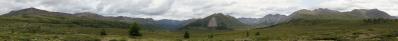
The first panorama of Pangong that I presented was taken very close to its W end - actually, better than end, beginning, since that is the only access for nearly all travellers.
Here we are already at the door of Merak, which is the last location accessible to foreigners. To visit Pangong, as any other location within 40 km from the very sensible border with China, you need to be equipped with an Inner Line Permit, which can be obtained only in Leh and lasts one week. But at Merak you have to stop, in spite of the permit. On some Internet page you read that guided groups of Indian citizens can push further, but on the place I did not have any confirmation and, moreover, conditions change remarkably from year to year, in accordance to the current political situation.
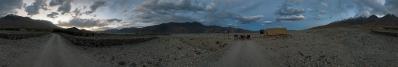
Since hope is said to be the last to die, with Edoardo we had investigated if there was some way to go on to Chushul, and then to undertake the long traverse to Tso Moriri. This would have required traversing several high passes, culminating in the 5420 m Kaksung La, and would have yielded a dream tour, joining the two dream lakes of the Indian Tibet.
This could not become reality, however, so we hat to invent on the fly an alternative dream tour, featuring the concatenation of Chang La, Wari La and Khardung La, each more of 5300 metres. Consequently, for us Merak became just a return trip at the beginning of the permit week. It was, however, an incredible experience in totally desert places with wonderful and always changing light.
The identification of the peaks in the mountain range south of the lake will be a difficult job. For now, I have simple reported Udeuschle heights. The pyramid rising from behind at 235° could be what on the Nelles Map is marked Meruk (sic), 6587 m. Google Earth gives, as culminating point of the range, a Kangju Peak, set at 6690 m by a climb with the mouse. Its east ridge should be the white one that disappears at 196°; Udeuschle already gives 6580 at that point.
At 126°, on a prominent point in shadow, you find a label saying "7 km to border post". it is a very isolated military installation, that can be spotted with Google Earth, and lies right before the area that on the Nelles Map is marked "under the administration of China - claimed by India".
12 HF, Canon G1X, 28 mm equiv, f/5.6, 1/400 sec.
Larger: https://bit.ly/3oGitS0
GPS track: http://www.wikiloc.com/wikiloc/view.do?id=10832358
Klaus Brückner, Hans-Jörg Bäuerle, Mentor Depret, Friedemann Dittrich, Gerhard Eidenberger, Jörg Engelhardt, Felix Gadomski, Johannes Ha, Leonhard Huber, Martin Kraus, Wilfried Malz, Edoardo Martelli, Giuseppe Marzulli, Steffen Minack, Uta Philipp, Jan Lindgaard Rasmussen, Danko Rihter, Christoph Seger, Konrad Sus, Jens Vischer
|
 |


Comments
Tonight I have finally... prepared the panorama, writing down the description, setting the labels (well, just numbers), and also reloading the picture, with a slight increase in both luminosity and colour temperature.
This is what, on my screen, matches best the memory. Then it is a hard challenge to establish which of the two, screen or memory, is less reliable!
Cheers, Alberto.
Leave a comment