|
Maybe some people remember that this was one of the old disappeared Patagonian panoramas - possibly the first one, but I do not remember.
I do not know whether it is the case to restore some of them, say, at least the "instructive" ones. To place them without boring excessively the Panorama Photo community, I tried to contact the master of Mountain Panoramas, but this came to no effect.
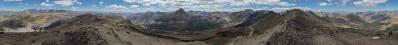
So... here we are, and let me make an experiment with this one, which acts indeed as a nasty shock, putting together as it does 1) the dejà vu effect, 2) the gray weather and 3) the new Schnitt with the horribly cut rock tower, once confined at the border, and now in evidence. Namely, I thought that the frightening object could rise there, to remember that the photo was taken but the casual Wanderer with absolutely no access to that stuff.
Le me observe how painfully this acts on the Betrachter, and then either describe it or withdraw it.
12 HF, Canon G1X, 28 mm equiv, f/7.1, 1/500 sec.
Larger: https://bit.ly/3CdZbwE
GPS track: www.wikiloc.com/wikiloc/view.do?id=12060871
Labels and heights mostly after: Buscaini - Metzeltin, "Patagonia - terra magica per viaggiatori e alpinisti", 1998.
---------------------------------------------------------------
The rock tower obstructing the view is the Espada (sword), forming with Mascara and Hoja a powerful line connecting the Cuernos to the Torres. Note that you can also find Espalda, which however has a completely different meaning (shoulder). Espada seems to me more proper.
Note that the most known profiles of the Paine, namely Cuernos and Torres, are typically observed/photographed separately: the former mostly from south, the latter from NW. But on the field, as shown here, they are really close!
Besides connecting Cuernos ant Torres, this ridge separates the valley which lies at the heart of the massif, namely Valle del Francés, from its minor sister Valle Pingo, sometimes called Valle Bader. When one speaks of W Paine circuit, the central cusp of this W (W for its the shape, nothing to do with west, since it lies all on the SSE side of the massif) is the Mirador Británico in the middle of the Valle Francés. In the present image it lies slightly hidden, down in the vegetated area, behind the rocks right of the Espada. Note that nearly all nationalities are represented here, since at the beginning of the valley one also finds the classical Campamento Italiano.
Unfortunately, the wonders of the high valley remain unknown to the crowds, since technically it is forbidden to walk past Británico. Actually, in the Paine, in order to walk outisde the trekking areas you would need a permit from both CONAF (Corporación Nacional Forestal) and DIFROL (Dirección Nacional de Fronteras y Límites). This is why I dubbed all my viewpoints in the Paine as Illegal Summits. Incidentally, the ascent to the third one was not motivated by specific panoramic proposals, as you can easily infer from the weather. The point was that Juanuary 17 is the birthday of my mother, and in the Paine mobile phones works only in very confined areas, among which there is Laguna Amarga, which is one of the doors ot the park. So, when from Valle Francés i see a formidable scree slope leading to a tiny saddle in front of the Amarga region, I thought that perhaps there could be a bit of signal there on. This, of course, turned out to be only an illusion. However, in place of signal I found, among the granites enclosing the couloir, a rock ledge leading up, with an easy scramble (could be at most II+), to the present spot.
It is curious to note that precisely 60 years earlier, on 17-01-1954, the first attempt to the Paine Grande (highest summit of the region, unfortunately in clouds here) ended in tragedy due to a fall of seracs, with the death of two climbers belonging to the Club Andino Bariloche. Three years later, the CAB was again in action, this time... illegally, because the climbing permit had been secured to the Italian expedition lead by Guido Monzino - the future leader of the first sucessful Italian Everest expedition, 1973. The Argentians reached only to within 40 metres from the summit ridge, while the Italians some week later achieved the first ascent. Among them, names as Bich, Carrel, Pellissier, which for hosts of the Western Alps should not be unfamiliar.
Formidable is also the climb of the SE pillar of the Fortaleza, which pops out so proudly here. This was achieved by an English party in 1979, with 13 days (!!) of continuos climbing. Due to storm and frostbite they only reached the top of the granites, renouncing to the 200 m upper belt of treacherous dark schistes. These are the true signature of the Paine: delice for photographers, but cross for climbers.
Behind the saddle between Fortaleza and Torres there is the wonderful and of course forbidden Valle del Silencio, proudly dominated by Fortaleza and Escudo (the latter nearly totally hidden here).
For an understandng of this site, see N. 21368.
Behind the saddle between Torres (here you see only the South one, the other being aligned with the viewpoint) and Paine Chico there is the main Mecca of trekkers, namely, the Mirador Torres. To understand what happens on that side, I recommend a look at www.panoramio.com/photo/124667700 where you find the same characters visible here, including the powerful belt of black schistes leading to Cerro Almirante Nieto, NE stem of the Paine massif, recognizable even from the region of Lago Argentino. To check this last point, you need to zoom deeply into www.panoramio.com/photo/124067219
Michael Bodenstedt, Arno Bruckardt, Klaus Brückner, Hans-Jörg Bäuerle, Mentor Depret, Jörg Engelhardt, Felix Gadomski, Johannes Ha, Martin Kraus, Giuseppe Marzulli, Uta Philipp, Jan Lindgaard Rasmussen, Danko Rihter, Christoph Seger, Konrad Sus, Jens Vischer
|
 |


Comments
Cheers, Hans-Jörg
NB:
Thx Alberto, for your explanation for the elevation data of Cerro Torre ...
So, the picture stays, and Is now endowed with a hopefully "instructive" geographical description.
Cheers, Alberto.
Leave a comment