|
The Taglang La is the highest pass crossed by the Manali - Leh Highway, although the most important remains the one (Baralacha La) crossing the main watershed (Great Himalaya Range) between India and Tibet. Taglang La, on the other hand, crosses the minor range south of the Indus Valley, that is, south of the "kernel" of Ladakh. This range also called Zanskar Range from the name of the long Zanskar valley lying SW of central Ladakh. North of it, between the Indus and the Shyokh valleys, there are the three big passes that were already briefly discussed in N.18283.
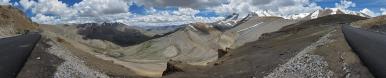
As you see, the gradients of the road are very smooth, because at 5000 metres there is half the oxygen that one has at sea level, and this affects not only the engine of cyclists but also other kinds of engines... For example, in what inside the picture is named "asphalted final stretch" (following the "very dusty ascent") I was accompanied, in my climb at no more than 10 km/h, by a little Tata - this is the name of the main Indian motor brand. Find two Tatas along the lower border of the picture - as you see, they resisted to both the pass and the (even more dangerous) Stempel of the photo adjuster.
As you also see, the mountains in this stretch of the Himalaya are not aesthetically unbeatable. However, I was curious to stitch this picture in order to answer a question, namely, whether from this viewpoint we had seen the Saser Kangri group lying 150 km north. Saser Kangri (7672), in southern Karakoram, happens to be the highest peak in Ladakh. In 2010, right after having climbed the Somoni peak, I discovered in the list of highest mountains
en.wikipedia.org/wiki/List_of_highest_mountains
that the entry immediately before, namely, Saser Kangri II, represented the highest peak then unclimbed. Curiously enough, nowadays the crowns has passed to a... higher sumnit, that of a previously unlisted mountain.
Since neither Edoardo nor I have ever been to the "tough" Himalayas, we had also never seen anything higher than the Somoni. So, we were curious to see whether this record could be beaten, but Udeuschle seems to witness that the mountain was in clouds.
Of course here, besides the theme "high mountains", there is also the theme "high passes". For people interested in the controversial topic "highest motorable passes" I report some data. Note that, in these regions, when one come sto numbers it is virtually impossible to find two sources in agreement...
I listed the passes crossed by us, following the chronological order, which also coincides with the acclimaziation-friendly arrangement. The data stem from three different sources:
1) the 1:350.000 Nelles map Ladakh - Zanskar, the most detailed as far as I know. One value is a clear mistake;
2) the book: "Himalaya by bike", by Laura Stone, Trailblazer Publications;
3) my GPS.
_MAP BOOK GPS
3978 3988 3946 Rohtang La
4890 4918 4903 Baralacha La
4740 4937 4933 Nakeela La
5077 5077 5077 Lachlung La
5320 5300 5343 Taglang La
5360 ____ 5372 Chang La
5300 ____ 5309 Wari La
5360 5353 5368 Khardung La
The competing GPS track - presently still rather poor of information -
is www.wikiloc.com/wikiloc/view.do?id=10832402
24+01 jpg HF, the supplementary one needed to mask off a nasty pole that was on top: top consisting of the roof of a (presumably military) barrack.
Photos taken with the second, "spare" camera: Nikon D3300 with fixed 35mm (x1.5) lens, f/9.0, 1/400 sec.
30.000 pixel version: https://bit.ly/2IOju5R
For the original (57702 x 5589 pixel) I need to find some other shelter!
This is also the first project that I stitch with Hugin 2015 - up to now, I was still working with Hugin 2011.4. With Enblend the computation took several hours but, being tendentially conservative, I did not try the new blender Verdandi yet...
Hans-Jürgen Bayer, Jörg Braukmann, Klaus Brückner, Hans-Jörg Bäuerle, Friedemann Dittrich, Jörg Engelhardt, Johannes Ha, Leonhard Huber, Heinz Höra, Thomas Janeck, Martin Kraus, Wilfried Malz, Giuseppe Marzulli, Jan Lindgaard Rasmussen, Danko Rihter, Patrick Runggaldier, Arne Rönsch, Christoph Seger, Konrad Sus, Jens Vischer, Alexander Von Mackensen
|
 |


Comments
As you see, I am able to spot them even in Crete...
Cheers, Alberto.
LG, Alberto.
Leave a comment