
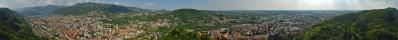
| Cycle through labels: |
|
| Châteauneuf-Val-Saint-Donat |
| Montagne de Lure, 1534m |
| 748 m |
| Rocher d'Arambre, 1434 m |
| Aubignosc |
| A51 Autoroute (Gap-Marseille) |
| SISTERON |
| Montagne d'Aujour, 1834 m |
| Montagne de la Baume, 1147 m |
| Salignac |
| Sommet de Gache, 1340 m |
| La Durance |
| Montagne de Jouere, 1886m |
| Volonne |
| Château-Arnoux |
| Chateau de Arnoux |
| Sommet du Ruth, 1280m |
| Lac de l'Escale |
| L' Escale |
| Barrage de l' Escale |
| La Pourachere, 861m |
| Canal EDF |
| Malijai |
| Théatre Durance |
| La Durance |
| Plateau de Puimichel |
| usine chimique |
SOLVED RIDDLE.
In the last trip to France I mostly followed the river Durance. The Durance is a river that rises in Briancon (the Italian-French border) and flows into the Rhone near Avignon. http://de.wikipedia.org/wiki/Durance |
||||||||||||||||
|
|||||||


Comments
Saluti Wolfgang
@Jörg: Justly :-)
40 km away, to the left of the Sommet du Ruth (not visible in the pano), it is the place where crashed the plane Germanwings.
Saluti Wolfgang
Leave a comment