
| Cycle through labels: |
|
| Ile de Riou |
| Ile Maire |
| Cap Croisette (pano 18374) |
| Phare du Grand Rouveau |
| ILE DES EMBIEZ |
| Massif de Marseilleveyre, 432m; 43Km |
| (MARSEILLE) |
| Port Saint-Pierre-des-Embiez |
| Grande Candelle, 454m |
| Baie de Cassis |
| Mont Puget, 563m; 37Km |
| Notre-Dame de la Garde (pano 16937) |
| Sémaphore du Bec de l'Aigle, 330m |
| Bec de l'Aigle, 155m |
| Cap Canaille, 363m; 27Km |
| Port du Brusc |
| La Ciotat |
| Mont Carpiagne, 646m |
| Baie de La Ciotat |
| Mont Lantin, 570m |
| Pointe du Deffend |
| Ile Rousse |
| Ile de Bendor |
| Ponte de la Cride |
| Bandol |
| Garlaban, 714m |
| Tête du Grand Puech, 778m |
| Pointe Negre |
| Mont Cruvelier, 574m |
| Sanary-sur-Mer |
| Roque Forcade, 936m |
| Pic de Bertagne, 1042m; 31Km |
| MASSIF DE LA SAINTE-BAUME |
| Joug de l'Aigle, 1148m |
| Six-Fours-les-Plages |
| Signal des Béguines, 1148m |
| Fort de Six-Fours |
| Mont Caume, 804m |
| La Seyne-sur-Mer |
| Grand Cap, 782m |
| Mémorial du débarquement en Provence |
| Station du téléphérique sur le Mont Faron |
| Pointe de Valbourdine (pano 16909) |
| Point Sublime |
| Arsenal (military port) |
| Mont Faron, 584m |
| Fort de la Croix Faron |
| TOULON |
| Mont Coudon, 702m; 17,7Km |
| Fort Balaguier |
| La Tour Royale |
| Le Haut Montet, 1335m; 114Km |
| Baie du Lazaret |
| Fort Saint-Louis |
| Grande Jetée |
| Isthme des Sablettes |
| Notre-Dame des Anges, 780m |
| Port Pin Rolland |
| Fort du Cap Brun |
| PRESQU'ILE DE SAINT MANDRIER |
| Cimetiere militaire franco-italien |
| Fort de la Croix des Signaux |
| Pointe de Marégau |
| Mont des Oiseaux, 280m |
| Phare du cap Cépet |
| Pointe du Rascas |
| Cap de Carqueiranne |
| Plage de l' Almanarre |
| Cap Blanc |
| Route du Sel |
| Pointe de la Calle Rousse, 72Km |
| ILE DU LEVANT |
| PRESQU'ILE DE GIENS |
| ILE DE PORT-CROS |
| Fortin de la Vigie, 199m; 45Km |
| Pointe d'Escampobariou |
| Île du Grand Ribaud |
| ILE DE PORQUEROLLES |
| Sémaphore de Porquerolles, 140m; 32Km |
| Sémaphore du cap Sicié |
| Cap d'Arme |
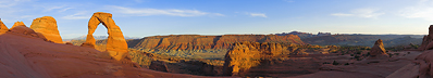
Notre-Dame du Mai (352m) is a church located on the highest point of the Massif of Cap-Sicié.
I think it is one of the most beautiful panoramic sights in all of France. It is located on the top of one of the highest sea cliffs in Europe. From the church you can see the entire French Mediterranean coast between Marseille and Saint Tropez (almost). 9 photos; 60 mm (full format); f8; 1/1250 sec.; 100 ISO. |
||||||||||||||||
|
|||||||


Comments
Comment by Wilfried poses an interesting question: where is the end of the Cote d'Azur?
The Cote d'Azur is not a well-defined administrative border. Plus or minus everyone is in agreement that the Cote d'Azur begins in Menton (the French-Italian border) and that Nice (Nizza) is the capital the Cote d'Azur. But where does it end?
For almost all Italians the Cote d'Azur ends at Esterel or at most in Saint Tropez. For the Germans, I understand it is more or less the same thing.
But the opinion of the French is perhaps different. For several French the Cote d'Azur ends practically in Marseille.
According to this last opinion, this panorama would show the most western part of the Cote d'Azur.
http://de.wikipedia.org/wiki/C%C3%B4te_d%E2%80%99Azur
http://fr.wikipedia.org/wiki/C%C3%B4te_d%27Azur
Leave a comment