|
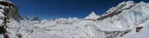
A typical portrait of the Hima-alaya, literally, "abode of snow", from one of its high passes.
To reconstruct the history of the Amphu Lapcha, the best approach is to start from the 1951 Everest reconnaissance, led by the legendary Eric Shipton. This was the very first exploration from Nepal, and it was in Nepal that the British climbers were reached by a strange cable from New Zealand, asking whether four NZ climbers engaged in the Garhwal could join the expedition. "Who are they and what do they want from us?", was the obvious first, but suddenly Shipton - facing the opposition of everybody - changed his mind, feeling that the presence of potentially strong young people could be useful. The meeting with the newcomers happened en route: "Then, for the first time, we learnt their names; they were Earle Riddiford and Edmund Hillary. My momentary caprice was to have far-reaching results."
The expedition had to discover everything about the route that nowadays we all know. "They had set out to find the answers to four questions. Could a way be found up the ice-fall entrance to the Western Cwm, which would be safe for laden porters? Were the slopes leading from the Cwm to the South Col climbable? Was the SE ridge from the col as easy as it appeared from air-photographs? Were the autumn conditions likely to be more favourable than those in spring?"
[Kenneth Mason, Abode of Snow. A History of Himalayan Exploration and Mountaineering]
The main obstacle was soon recognized to be the Khumbu Icefall.
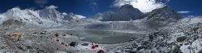
"Between our two spells on the ice-fall we spent the time exploring the unknown country in the immediate vicinity of Everest, Ed and I to the east, the others to the west. Our main objective was to find a way through the tangle of ranges to the Kangshung Glacier, which flows from the eastern flanks of Everest, so as to link up with the explorations of the 1921 expedition and our journeys in 1935. The Sherpas told us that there was a way over to Tibet from the head of the Imja Khola, though none of them claimed to know it; but we found that the upper valley was enclosed by an unbroken cirque of very high mountains, dominated by Lhotse. However, we managed to cross a difficult col to the south into the basin of the Hongu Khola, a region unknown to the Sherpas"
[Eric Shipton, That Untravelled World]
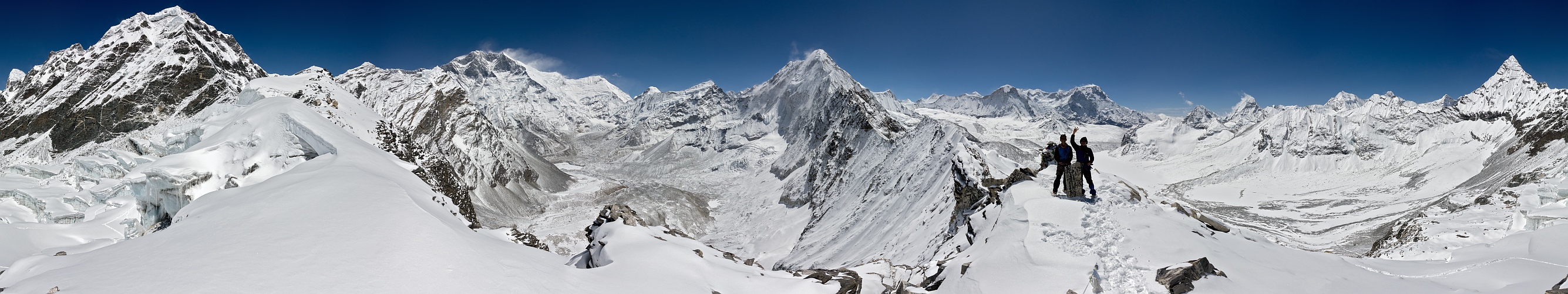
This marks the birth of the Amphu Lapcha as a feasible link between the Imja Khola cirque, well visible in the panorama, enclosed between Lhotse and Baruntse, and the high Hinku valley, linked to the adjacent Barun valley and thus to the Makalu region by easier passes.
It was in this trip invented together with Shipton that Hillary developed a passion for the Makalu.
He was back to Nepal only in 1960, with a Himalayan Scientific Expedition that he had conceived while operating at the McMurdo base, in Antarctica (!). This expedition had many strange adventures, among which also a glorious but unauthorized first ascent to the Ama Dablam.
"The unauthorized climb angered Nepalese authorities, who threatened to shut down the entire project. Hillary had to travel to Kathmandu and spend several days smoothing things over. That unpleasantness settled, Hillary turned his attention to Makalu, a mountain he had hoped to climb ever since his first visit to the Barun Valley in 1951 with Eric Shipton. But Makalu was not a lucky mountain for Hillary. He suffered a mild stroke in early May after having climbed to 21,000 feet and had to be evacuated."
[M. Isserman and S. Weaver, Fallen Giants. A History of Himalayan Mountaineering from the Age of Empire to the Age of Extremes]
After this accident, Hillary concluded the 1960 expedition at lower altitudes. In particular, he negotiated with the villagers of Khumjung permission to transport their famed Yeti scalp (still nowadays proudly exposed in the local gompa) to the US for scientific examination. In exchange for this, he promised to collect funds for the building of a secondary school, which is still nowadays a reference for instruction in the Khumbu.
This said, on the steep path to Khumjung I found a 15-year old girl struggling under the unforgiving sun of the local 3700 m with an incredible load of yak dung, which is commonly used as fuel. I relieved her of part of the load, but also the reduced load forced her to periodic stops, at which she repeated in a mechanical and resigned tone "Because my family is very poor", as she were asking forgiveness for some heavy guilt. Above us, at regular intervals of maybe five minutes helicopters cut the air to ferry tourists, both Westerners and Japanese, to the luxury Everest View Hotel, where a drink on the panoramic terrace costs maybe more than the daily income of a porter ferrying 30-40 kg across a pass like the Amphu Lapcha.
And, in the background, another even more regular stream of helicopters followed the Khumbu valley to reach the Everest base camp, which this year stretched, measured with my GPS, for no less than 1700 m from one end to another.
The reader can make his own Betrachtungen about how much Edmund Hillary's spirit has been taken on in our days!!
As for Shipton, at the crucial moment he was brutely "fired" as expedition leader by the Himalayan Committee who chose for the 1953 assault a man of military discipline - one coming indeed from the army, colonel John Hunt. Shipton, the man who from the tea plantations of Kenya had risen to be the foremost Everest explorer, and ho even "invented" one of its first ascensionists, namely Hillary, comments in retrospect the whole story as follows:
"It is possible, even probable, that in time men will look back with wonder at our feeble efforts, unable to account for our repeated failure, while they themselves are grappling with far more formidable problems. If we are still alive we shall no doubt mumble fiercely in our grey beards in a desperate effort to justify our weakness. But if we are wise we shall reflect with deep gratitude that we seized our mountaineering heritage, and will take pleasure in watching younger men enjoy theirs."
[Eric Shipton, Upon That Mountain]
10 HF, Zeiss Vario-Sonnar 24-600 at 24mm equiv, f/8, 1/1250 sec.
Data after Udeuschle and Nepa Maps NE517, Everest Base Camp and Gokyo 1:50.000
Coordinates: 27.86853 86.91814
Larger: https://bit.ly/3ifQUyz
It is strongly recommended to look also at the rather thorough description made at the page https://www.himalaya-info.org/amphu_labtsa.htm
Sebastian Becher, Alvise Bonaldo, Winfried Borlinghaus, Klaus Brückner, Hans-Jörg Bäuerle, Jörg Engelhardt, Klaus Föhl, Johannes Ha, Johann Ilmberger, Matthias Knapp, Martin Kraus, Dieter Leimkötter, Wilfried Malz, Giuseppe Marzulli, Steffen Minack, Christian Mittermair, Jan Lindgaard Rasmussen, Danko Rihter, Patrick Runggaldier, Christoph Seger, Björn Sothmann, Michael Strasser, Arjan Veldhuis, Jens Vischer, Alexander Von Mackensen, Augustin Werner
|
 |


Kommentare
Wunderbar fotografiert, sauber zusammengefügt und dazu noch mit einer interessanten Story garniert.
Kommentar schreiben