Beyond the western part of Vänern   73295
vorheriges Panorama
nächstes Panorama
Himmelsrichtungen ein / ausHimmelsrichtungen ein / aus
Details / LegendeDetails / Legende Marker ein / ausMarker ein / aus Übersicht ein / ausÜbersicht ein / aus   
 Durchlauf:   zum ersten Punkt zum vorherigen Punkt Durchlauf abbrechen
Durchlauf starten
Durchlauf anhalten
zum nächsten Punkt zum letzten Punkt
  verkleinern
 

Legende

1 Hunneberg table mountain 153 m, 59 km
2 P. 167 m, 91 km
3 Halleberg table mountain, 59 km
4 Vänersnäs, 45 km
5 P. 87 m, 64 km
6 Limsjöberget 165 m, 91 km
7 Kålland
8 P. 167 m, 89 km
9 Eterberget 162 m, 78 km
10 Hindens Rev, 31 km
11 Gullstenen 205 m, 74 km
12 Bollungsåsen 190 m (Kroppefjäll), 70 km
13 Svindalsberget 230 m, 71 km
14 Lunnane 219 m, 70 km
15 Hjortens Udde, 44 km
16 Svileberg 240 m, 72 km
17 Skurtursberget 235 m, 72 km
18 P. 231 m, 71 km
19 Dammbergen 235 m, 72 km
20 Hattekullen 234 m (Kroppefjäll), 72 km
21 Funnebohögen 223 m (Brudfjället), 67 km
22 Bäckefors TV-mast, 74 km
23 Grönehög 251 m, 74 km
24 Otterstad church, 15 km
25 Janskulle 258 m, 72 km
26 P. 255 m, 74 km
27 Trinne Kulle 226 m (Brudfjället), 76 km
28 Kållandsö, 15 km
29 Rödkullen 194 m (Dalformationen), 69 km
30 Orreberget 231 m, 70 km
31 Trytebergen 224 m, 71 km
32 Naven lighthouse, 20 km
33 Vålekullen 240 m, 71 km
34 Skrällerudskullen 255 m, 72 km
35 Norra Klasgrundet lighthouse, 21 km
36 Björnhögen 255 m (Dalformationen), 72 km
37 Läckö Slott, 13 km
38 Vålekullen 266 m, 73 km
39 Oxakoffberget 254 m, 72 km
40 Strömsundet
41 Baljåsen 301 m, 76 km
42 Gölekullen 269 m (Dalformationen), 74 km
43 Stor-Eken, 13 km
44 P. 265 m, 81 km
45 Pålgrunden lighthouse, 22 km
46 Hognerudsknatten 256 m, 81 km
47 Nicktjärnsberget 291 m, 85 km
48 Sea mark, 21 km
49 P. 265 m, 92 km
50 Hallandaknatten 259 km, 86 km
51 Åskogsknatten 276 m, 90 km
52 Sea mark, 16 km
53 Korpberget 279 m, 97 km
54 Sea mark, 16 km
55 Mellanfjället 223 m, 82 km
56 Sundhöjden 284 m, 100 km
57 Ulvfjället 310 m, 96 km
58 Sea mark, 17 km
59 Nordtorpshöjden 308 m, 100 km
60 Tjäderåsen 229 m, 85 km
61 Basthöjden 266 m, 96 km
62 Hösåsfjället 200 m, 85 km
63 Torrskogshöjden 269 m, 99 km
64 Gravhöjden 234 m, 96 km
65 Lurö, 23 km
66 Margaretas Ås 257 m, 98 km
67 Svarthulten 275 m, 98 km
68 Stångudden lighthouse, 22 km
69 Gunnarsholmen lighthouse, 30 km
70 Sea mark, 20 km
71 Saxhöjden 257 m, 96 km
72 Skrussrudsåsen 154 m, 74 km
73 Värmlandsnäs, 38 km
74 Ämön, 29 km
75 Daltjärnshöjden 170 m, 75 km
76 Stora Bratt, 24 km
77 Storön, 26 km
78 Stora Klubben lighthouse, 31 km
79 Svartskär
80 Stensbergsåsen 130 m, 72 km
81 Lindholmen
82 Timmermon 115 m, 71 km
83 Näshuvudet, 35 km
84 Härjudden, 43 km
85 Furholmen
86 Liskären, 45 km
87 Edsbonden 140 m, 81 km
88 Gruvöns bruk paper factory, 83 km
89 Rosnäsudden, 48 km
90 Storholmen, 52 km
91 Stutakleven 175 m, 92 km
92 Lompberget 115 m, 88 km
93 Risåsen 127 m, 91 km
94 Storhöjden 217 m, 107 km
95 Smedstadbergen 172 m, 97 km
96 Djurö archipelago Nationalpark, 25 km
97 Stora Enso paper factory, 80 km
98 Djurö archipelago Nationalpark, 27 km
99 Hammarö peninsula, 75 km
100 Djurö archipelago Nationalpark, 30 km
101 Galtryggen 109 m, 93 km
102 Storåsen 251 m, 117 km
103 P. 245 m, 116 km
104 Timmeröarna islands, 78 km
105 Härö, 75 km

Details

Aufnahmestandort: Kinnekulle (306 m)      Fotografiert von: Jan Lindgaard Rasmussen
Gebiet: Sweden      Datum: 2016-08-03, 12:45
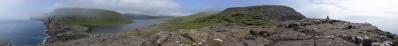
A rather long teleview, perhaps in a kind of dull colour tone. 4 features here: documentation of long distances (boring, I know...), the Dalsland relief, and the two peninsulas of Kålland and Värmlandsnäs.

If you look at the map, you can see the two prominent peninsulas reaching out for each other. They divide the lake into two portions; the lesser western part is called Dalbosjön. It is named from the landscape of the western part of the lake, Dalsland. The names mean "the lake of the settlement in the valley/See der talsiedlung" and "land of the valley/Talsland" resp. Sorry for my shortcomings, hope you get the meaning :-)

When you look at Dalsland, you most likely notice its relative prominent structure, and so you wonder what gave its name. The rugged terrain are a number of small fjälls; in western Sweden "fjäll" is used to describe a rugged, high and hostile landscape, unlike the rest of scandinavia, where it means the part of a mountain above the timberline. Between the fjälls and the lake, however, the low landscape, Dalboslättan, is very fertile, and this part gave the landscape its name.

Heinz noted in a previous pano, that many hills didn't have name, but was merely a P. xxx m. I happen to have a detailed (1:50.000) map of Kroppefjäll, and must confirm, that only a few hills have a name. Although severel hills are above 200 m, their prominence are most likely very little, and therefore not with a proper name.

The two peninsulas, and in particular Värmlandsnäs, have a large schärengarten. Not easy to see on the pano, but actually a lot of lighthouses and seamarks are scattered throughout here. An overview on this page: http://www.fyr.org/wiki/index.php/V%C3%A4nern

Interesting on location was to follow the weather development. The two previous days we stayed in Göteborg, and wanted the best weather for this trip (appr. 2 hours i car). The days before had nice weather, but also unpredictable showers. The forecast for this day promised clear weather early in the day, but with a broad weather front coming in from the west with a prolonged period of rain in the afternoon. On the first overview pano (12:11), we are in clear sunshine, and the front seems far away. On the next pano (12:29) the weather was still nice, but it felt like the bite was somewhat gone. And on this one, it is clearly darker to the west, with only the trans-vänern locations to the north still sun bathed. An hour later in the car, the rain came pouring down...

Pano made from 70 LF pics (RAW), 300 mm handheld, f/7,1, 1/1250 sec, iso-100, developed in DPP (daylight, faithful, moderate sharpness, ALO off), stitched in PTGui pro, contrast adjustment, downscaling and sharpening in Irfanview.

Kommentare

Great show with far distances!
LG Jörg
11.09.2016 10:55 , Jörg Nitz
"The Master of lowland Tele-Panoramas" has struck again ... ;-) - great show, Jan!!

Cheers, Hans-Jörg
11.09.2016 11:57 , Hans-Jörg Bäuerle
I like it completly, but the points at the edge are the cherry on the cake.
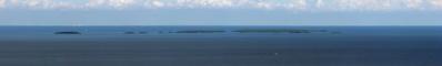
It might be very rare to see a 249m hill 117km away from a point not much higher, I guess.
11.09.2016 12:46 , Steffen Minack
Unbelievable that this is a lake and not a part of the sea.
11.09.2016 23:36 , Jörg Braukmann
Keineswegs langweilig, sondern eine sehr interessante Fernsichtaufnahme.
13.09.2016 17:00 , Friedemann Dittrich
So, at last...description updated, and labels after my best ability. Views exceeding 100 km are marked with red. It was difficult finding it, but at last I found a map site (www.hitta.se), where one can find names on most prominent hills and mountains just by zooming in. Thank you for the attension!
15.09.2016 21:51 , Jan Lindgaard Rasmussen
Was für ein Streifen, Jan!
20.09.2016 21:07 , Arne Rönsch

Kommentar schreiben


Jan Lindgaard Rasmussen

Portfolio

Weitere Panoramen

... in der Umgebung  
... aus den Top 100