|
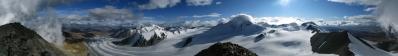
While shooting these photos, I was convinced to be for some dozens of meters in Chinese territory. From subsequent studies, however, I understood that I actually was on the Russian side, since the "triple point" involving Russia, China and Mongolia does not lie on the main summit, but on the little bulge 4082 m lying 1 km south. In any case, I think that the name Nairamdal (meaning friendship) applies to the highest point, although the cartography of the region is very confused.
Only 40 km W from here there is another "triple point", namely, the one involving Russia, China and Kazakistan. From there rightwards, the Kazakh-Russian border points N to reach the Gora Beluha, culminating point of the Altai, from where it continues W without interruption to the Caspian Sea. Leftwards, on the other hand, the Kazakh-Chinese border stretches for more than 1000 km, just to meet Kirgizistan. But when this happens the mountains have already taken on another size, and we are among the 7000m peaks of the Tien Shan.
The present panorama begins in Mongolia, with the W flank of Mount Huithen closing the view. Then it enters China, where the 4082 m bulge largely hides the valley of the Przevalsky glacier, the only one on the Chinese side enabled to compete with the Mongolian side Alexandroff and Potanina glaciers (see N.9744). Here we also have the Udeuschle-computed maximum distance, lying 270 km far, already inside the Junnggar Pendi, the desert north of Ürümqi, in northern Sinkiang.
Incidentally, it is worth to note that in all this section the Udeuschle rendering appears to be somewhat unreliable. For example, at both 211.5° and 252.5° it draws non-existing sharp horns while, on the other hand, of the powerful triptych near 260°, reminiscent of our Gran Zebrú - Zebrú - Ortles, it draws only the "Ortles", that is, the rightmost summit. Somewhere still on its right is hidden the triple point with Kazakistan. The large marshy plain is already in Russia.
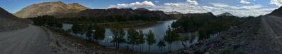
In this lonely spot, in the late afternoon, I was comforted by the sound of the waters flowing from the glaciers spread out like a mantle on the northern slopes of the mountain. In such immense spaces I was not able to evaluate their distance, but from time to time I had the "forbidden thought" that a 1.30-2 hour rush down the scree-covered ribs bordering the glaciers would have brought me onto the Ukok plateau, well close to the kurgan site of the Altai Princess (see N.8227).
Behind the plateau one sees the Chuyskiy mountain range, binding the Katunskiy range (the one featuring the Beluha) of the Altai to the Sayan range, extending eastwards until Lake Bajkal. The above chains are named after the rivers Katun and Chuya, the main branches of the great Siberian river Ob, featuring among its sources also the waters that were lulling me.
The Southern Chuyskiy in the foreground hide almost totally the higher northern chain, of which only some snowy peaks emerge: among them, the mighty 4177 m Maashey-Bashi. The northern chain is also said to hide fabulous glaciers and mountains, such as the triptych formed by the Krasavitsa (Beauty), Mechta (Dream) and Skazka (Fable) peaks. Northern and southern chain are joined by the so-called Karaghem Connector Range.
Curiously enough, nearly the whole of the region depicted here is drained by the Ob-Irtysh system. Namely, the farthest branch of the Irtys originates in southern Mongolia, from the flanks of the sacred mountain Mönkh Khairkhan Uul (some 200 m higher than our Mönch...). Then it crosses northern Sinkiang and western Kazakistan before bending decidedly north. Ob and Irtysh meet at 62° N and flow into the sea right at the Polar Arctic Circle, after 5568 km. More precisely, they still need the 800 km of the narrow Ob gulf, a sort of wide fjord, to get to the open Arctic sea.
The lower mountains beginning at the right end of the panorama separate the Ob-Irtysh basin (3 millions square km) from the Yenisey basin. Where the panorama ends, we find these mountains pointing again towards the Mongolian border, where the culminating peak is the Mongon Uul (see N.9272).
The history of the Yenisey is very similar to that of the Ob. The main branch, the Bolshoi (great) Yenisey, originates in Northern Mongolia and flows directly through the Tuvan Republic. But the Horidol Saridag (see N.9020) separates these waters from others following a much more tortuous way: they take the direction S, arriving close to Ulaanbaatar. Then they bend and, under the name of Selenga, enter Lake Bajkal at 90° with its rift, exiting, likewise at 90°, under the name Angara. The Angara meets the mainstream Yenisey at some 58° N, and flows together with it to the Arctic, which they reach at a distance of 300 km (very little on a Siberian scale) from the mouth of the Ob fjord. But the Selenga-Angara-Yenisey system turns out to be 18 km shorter than the Ob-Irtysh: only 5550 km...
The place is close to what the geographers call the Continental Pole of Inaccessibility, that is, the point of Eurasia lying farther from any sea. From this point, lying in Northern Sinkiang, one can draw a circle of 5200 km diameter lying entirely on mainland, tangent SE to the Gulf of Bengala, SW to the Arabian Sea and N to the Arctic sea; for a little it misses a fourth tangency point with the Yellow Sea, E of Bejing. There is no general agreement on the precise location of this pole, since there is some controversy about whether the Gulf of Ob should count as a sea in this context. Wikipedia explains the topic in detail.
To end: there are recent (January 2012) news about the Altai Princess, whose excavation site, the kurgan named Ak Alaha 3, located 2 km W of Bertek, at 49.29990 87.56269, 2196 m, lies no more than 24 km from the standpoint of the photo, although slightly hidden behind a hill.
According to http://en.tuva.asia/197-altai.html a new dedicated museum will open in 2012 in Gorno-Altajsk to host the mummy, who is at least as important as our Similaun man. On the topic, I strongly recommend to have a look at the booklet whc.unesco.org/uploads/news/documents/news-433-1.pdf
The 29 pictures are taken around 4.30 pm in West Mongolian time, the one adopted in the aimags of Uvs, Bayan-Olgii and Khovd. Zoom 70-300 at 75 (x1.5), ISO 100, f/22, 1/250 sec.
GPS track: http://www.wikiloc.com/wikiloc/view.do?id=7179126
Larger color version: https://bit.ly/3RZrBTB
A BW version, with Udeuschle rendering superimposed in red, in order to show the global consistency of the work, as well as the local discrepancies: https://bit.ly/3MfyURE
Hans-Jürgen Bayer, Jörg Braukmann, Hans-Jörg Bäuerle, Jörg Engelhardt, Klaus Föhl, Felix Gadomski, Johannes Ha, Heinz Höra, Johann Ilmberger, Marius Klein, Martin Kraus, Wilfried Malz, Giuseppe Marzulli, Jan Lindgaard Rasmussen, Danko Rihter, Arne Rönsch, Wolfgang Schmähling, Christoph Seger, Robert Viehl, Jens Vischer, Augustin Werner, Beatrice Zanon
|
 |


Comments
Alberto, die von Dir markierte max. Distanz 270 km ist aber in Deinem Bild nicht sichtbar, auch nicht in Deinem ausgezeichneten Bild auf Panoramio. Der dort zu sehende Höhenrücken ist "nur" 102 km entfernt.
Incidentally, this panorama has taken me, for a variety of reasons, far more time and efforts than any other that I have published. A lot of spots that had accumulated on the sensor after a summer of travels in dusty regions. The names to retrieve on maps written in Cyrillic, with even Udeuschle and Google Earth going crazy at times, as reported in the discussion above. A remarkable amount of haze to put aside and, last but not least, a challenging white balance for which, in despair, I resorted to a strange left-to-right gradient. And all this for a composition that was far from aesthetically pleasant (have a glance at the thumbnail, it looks out frightening), but I hope that the documentary value was worth the effort...
Note: Now I have updated and revised description and labels according to the page www.summitpost.org/altay/363217, very basic but useful for the Russian Altai. At the same time, for coherence with the contents, I have moved the panorama to Russia.
Leave a comment