|
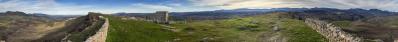
Den letzten Tag in Andalusien nutzte ich für eine Rundfahrt mit mehreren Stationen im Nordwesten meines Standquartiers in Ronda. Erstes Ziel waren die Ausgrabungen der Römerstadt Acinipo, die sich über ein im Westen steil abfallendes Plateau verteilen. An einem später ausflugsstarken Samstag war ich hier früh dran und konnte fast als erster die Weite genießen. Der Rundblick vom höchsten Punkt des Plateaus bot Anknüpfungspunkte an andere Stationen der vorherigen Tage. Leider zog gerade ein Wolkenband durch, im weiteren Tagesverlauf gab es dann wieder blauen Himmel. Mehr auf https://de.wikipedia.org/wiki/Acinipo
I used the last day in Andalusia for a round trip with several stops in the north-west of my base in Ronda. My first destination was the excavations of the Roman city of Acinipo, which are spread across a plateau that drops steeply to the west. I was here early on a Saturday that turned out to be very busy later in the day and was almost the first to enjoy the view. The panoramic view from the highest point of the plateau offered links to other stops from the previous days. Unfortunately, a band of cloud was just passing through, but later in the day the sky turned blue again. More at https://en.wikipedia.org/wiki/Acinipo
Olympus OM-D E-M5 III
M.Zuiko 12-45/4.0 Pro @18mm (=36mm KB)
16 HF RAW freihand, ISO 200, 1/500, f8
Lightroom Classic CC, Autopano Giga 4.4.2, IrfanView
360° Blickwinkel
Direktlink auf Google Maps: https://maps.app.goo.gl/Ydj7LTxKnksgTYBY7
Peter Brandt, Jörg Braukmann, Klaus Brückner, Hans-Jörg Bäuerle, Günter Diez, J. Engelhardt, Giuseppe Marzulli, Jörg Nitz, Danko Rihter, Björn Sothmann, Jens Vischer, Benjamin Vogel
|
 |


Comments
Gruß Klaus
Leave a comment