|
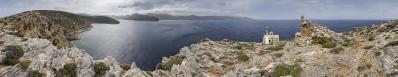
Am vorigen Nachmittag war ich auf der Wanderung die Insel entlang gut vom Gipfel des Profitis Ilias (auch hier zu sehen - #31024) über den im Inselinneren gelegenen nominellen Hauptort Chora (mit Gelegenheit zur Einkehr) nach Katapola hinabgestiegen und hatte dort problemlos mein nettes Pensionszimmer gefunden, in dem auch eine kleine Karaffe vom leckerern Insellikör Rakomelo (Tresterschnaps mit Honig) bereitstand. Der Ort erfüllte die aus den Erinnerungen von 2004 gespeisten Erwartungen, sogar die gute Taverne von damals gab es noch mit entsprechend gealtertem, aber noch genauso herzlichen Wirt.
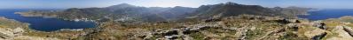
Wandernd wollte ich an diesem Tag eine Runde in Richtung Südwesten drehen. Zunächst steigt man oberhalb der wenigen Gassen hinter dem Hafen auf zur antiken Burg / Bergsiedlung von Minoa (Katapola heisst nach meinem Verständnis "Unterstadt") und gewinnt rasch an Sicht über die Bucht, deren Besiedlung genau genommen aus drei Dörfern besteht.
The previous afternoon, I had progressed well along the ridge of the island in descent from the summit of Profitis Ilias (also seen here - #31024) via the nominal main locality of Chora, situated in the island's interior, to Katapola and had found my nice room. The place fulfilled the expectations fed by the memories of 2004, even the good taverna from back then was still there with a correspondingly aged but still just as cordial owner.
On this day, I wanted to hike a round in the direction of the southwest. First one climbs up to the ancient castle / mountain settlement of Minoa (Katapola, as I understand it, means "lower town") and quickly gains a view over the bay, whose settlement, strictly speaking, consists of three villages.
Olympus OM-D E-M5 III
M.Zuiko 12-45/4.0 Pro @25mm (=50mm KB)
13 HF RAW freihand, ISO 200, 1/640, f8
Lightroom Classic CC, Autopano Giga 4.4.2, IrfanView
Direktlink auf Google Maps: https://goo.gl/maps/KETCvkYJrsNCo81f6
Hans-Jürgen Bayer, Müller Björn, Peter Brandt, Jörg Braukmann, Hans-Jörg Bäuerle, Günter Diez, J. Engelhardt, Dieter Leimkötter, Wilfried Malz, Giuseppe Marzulli, Matthias Matthey, Steffen Minack, Jörg Nitz, Jan Lindgaard Rasmussen, Danko Rihter, Arne Rönsch, Björn Sothmann, Jens Vischer, Augustin Werner
|
 |


Comments
Der rote Klecks rechts ist eine Wanderwegmarkierung?
Grüße,
Dieter
Leave a comment