Glacial toes of southeastern Vatnajökull   31085
previous panorama
next panorama
Orientation on / offOrientation on / off
Details / LabelsDetails / Labels Markers on / offMarkers on / off Overview on / offOverview on / off   
 Cycle through labels:   first previous stop
play
pause
next last
  zoom out
 

Labels

1 Hvannadalshnúkur 2110 m, 79 km
2 Hvannadalshnúkur secondary summit, 77 km
3 Steinafjall, 42 km
4 Kálfafellsfjöll 1000 m, 36 km
5 Jöklasel 1326 m, 37 km
6 Skálafellsjökull, 28 km
7 Hafrafell, 29 km
8 Heinabergsjökull 1300 m, 36 km
9 Heinabergsfjöll 1270 m, 29 km
10 Fláajökull, 23 km
11 Fláfjall, 21 km
12 Sandmerkisheiði
13 Glacier toe, 27 km
14 Hoffellsjökull, 23 km

Details

Location: Sefdalur (20 m)      by: Jan Lindgaard Rasmussen
Area: Iceland      Date: 2018-07-24, 20:41
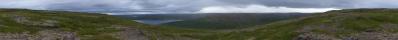
A tele study of the various so-called glacier terminus's of Vatnajökull in the southeastern end. The pano was made a short time before the last pano, in time to catch some sunlight on the highest fjell on Iceland, Hvannadalshnúkur.

Pano made from 18 pics (RAW), 70-200mm@200mm, iso-400, f/6,3, 1/400 sec, developed in DPP (cloudy, neutral, moderate sharpness), stitched in PTGui pro, scaling and sharpening in Irfanview.

Comments

Phantastic landscape !
2022/05/10 19:07 , Steffen Minack
Von hell nach dunkel. Sehenswert! VG Peter
2022/05/10 20:50 , Peter Brandt
Gloomy, Icy. And still so green in the foreground. Spectacular! Cheers, Martin
2022/05/14 21:10 , Martin Kraus

Leave a comment


Jan Lindgaard Rasmussen

Portfolio

More panoramas

... in the vicinity  
... in the top 100