
| Cycle through labels: |
|
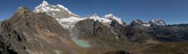
| Lagunas Mezapata |
| 5059, 21 km |
| Cerro Altaco |
| Jatunllacsa, 5630, 32 km |
| Paso Santa Rosa |
| Huantsan, 6395 |
| San Juan, 5863 |
| Tumagaranon |
| Maparaju, 5380 |
| Pucaranra, 6156 |
| Chinchey, 6309, 13 km |
| Cayesh, 5721 |
| Copap, 5567, 21 km |
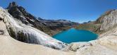
This is the 360° version of N.26890, alas without Laguna Tumarina. Indeed, I found no way to pack in both features, lake and full view...
Location: -9.493144 -77.284049 Larger: https://bit.ly/3CtLQ24 |
||||||||||||||||
|
|||||||


Comments
aber irgendwann muss es ja auch mal sehr viel schneien, wo sonst kämen die dicken eisgepanzerten Gipfel her.
Less that 10 mm per month in Jun - Aug.
However, as I experienced directly:
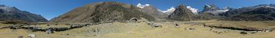
1) the climate is completey different from one to the other side of the Cordillera, and the situation depicted in N.26856 is very common;
2) the fine weather that I had in Carhuascancha, on the rainy side, turned out to be the exception. On the second-highest pass (Gara-Gara, 4830 m, panorama not yet published) of the Alpamayo - Santa Cruz loop, I had in a few hours a good deal of the monthly amount of rain/snow reported in books, and the same happened, only a bit more softly, a couple of days later, on the highest pass (Osoruri, 4860).
Climate is changing very quickly also in the Andes.
Leave a comment