|
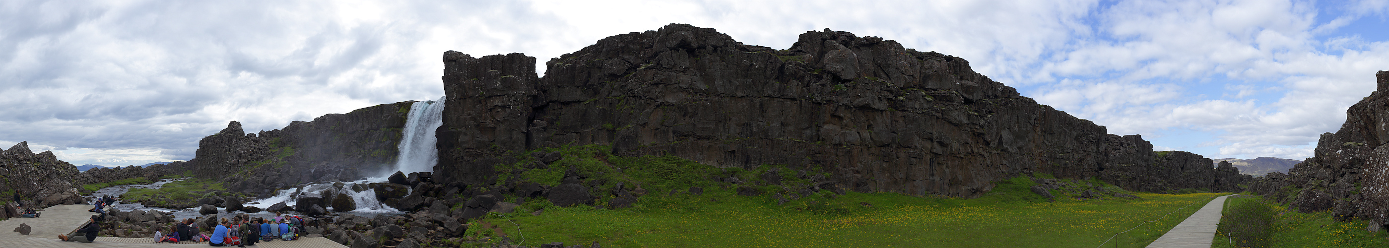
Þingvellir was our last attraction for our first day on Iceland, doing the so-called golden circle (Geysir-Gullfoss-Þingvellir). We didn't do a thorough inspection of the site, but focused on the northern end at the Öxaráfoss waterfall. The site is narrow and between walls of rock. The site is famous for being where the tectonic plates of America and Eurasia are being ripped apart.
Also, as a cultural site, the place was where the free men of Iceland met for discussing political issues in the viking age, hence the name "Þing" - pronounced as english "Thing", meaning "public meating", and extremely common in placenames everywhere in the nordic countries.
Pano made from 23 HF pics (RAW), 50 mm, iso-100, f/8, 1/250 sec, developed in DPP (daylight, neutral, moderate sharpness), stitched in PTGui pro, contrast, scale, and sharness in Irfanview.
Hans-Jürgen Bayer, Jörg Braukmann, Hans-Jörg Bäuerle, Friedemann Dittrich, Johannes Ha, Rainer Hillebrand, Leonhard Huber, Heinz Höra, Martin Kraus, Dieter Leimkötter, Wilfried Malz, Steffen Minack, Niels Müller-Warmuth, Danko Rihter, Werner Schelberger, Björn Sothmann, Arjan Veldhuis, Jens Vischer
|
 |


Comments
VG, Danko.
Da ich niemals dort selbst gewesen bin, bleibt mir nichts anders übrig, als das so zu tun, wenn ich dafür ein gewisses Interesse zeige. Mir kommt es so vor, als wenn auch Du davon ausgehst, der Betrachter müßte das alles schon selbst gesehen haben. Darauf bezieht sich auch meine erste Feststellung.
Hättest Du nicht in Deiner Beschreibung darauf hinweisen können, daß der Fluß, der hier einen Wasserfall erzeugt, aus einem See kommt, der hinter dem hier in der Mitte zu sehenden Felsrücken liegt. Auch diese Interpretation habe ich der Karte entnommen. Vielleicht ist das auch falsch.
Das nächste Mal zeige ich bei solcher Beschreibung kein weiteres Interesse an dem Bild, sondern like es ohne weitere Bemerkung nur deshalb, weil ich meine, daß es gut aus den Einzelbildern gestitcht wurde.
Leave a comment