|
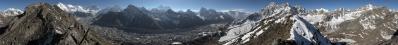
The altitude of the Standort is approximately that of the Monte Bianco.
If you put on top of it one Marmolada, you obtain the Cho Oyu.
The panorama is taken from near Thonak Tso, which is the fourth Gokyo lake.
The Gokyo lakes are all located on the W side of the gigantic Ngozumpa, longest glacier (36 km) of the Himalaya. Due to its latitude, the Himalaya does not have glaciers like those of the Pamir or Karakorum, where the Fedchenko and Siachen glaciers reach lengths of 77 and 70 km respectively.
The lakes are the following:
1. Longpunga Tso (Longabanga Tso), very little, 4710 m, lying on the opposite side with respect to Dragnag, a village which is touched by the classical Everest Three Passes trek;
2. Taujung Tso, 4740 m, halfway between first and third lake, and also between their sizes;
3. Gokyo Tso, also known as Dudh Pokhari, 4870 m, the most likely to be seen in photographs, since its shore hosts the village of Gokyo, and it is also visible from the nearby Gokyo Ri (see for example N.26242) and from Renjo La (a future panorama). It is also the most sacred, both for Buddhists and Induists;
4. Thonak Tso, 4870 m, the largest one, lying on the route to the rarely crossed Sundar La;
5. Ngozumpa Tso, 4990, below the 5553 m Ngozumpa Tse, and visible from it. Now marked in red in the summit panorama N.25710;
6. Gyazumba Tso, 5200 m, north of the same mountain. More than a lake, it is a system of little lakes - at least, that was its aspect from the summit. Do not look for it, however, in the quoted 360°. Maybe the lake will show up in some future work taken precisely from the summit rock. Near this lake system uses to be located the southern Cho Oyu Base Camp, used for the difficult ascent of the mountain from the Nepal side. We went in search for it, but we saw no tent since, as we had already been informed, there was no climbing party at all in action in Spring 2019. But going there for a direct check was a nice excuse to get still closer to the Cho Oyu...
As for the names of the last two lakes: Gyazumba and Ngozumpa are also the two branches joining (at the level of the sixth lake) into the main glacial stream
Location: 27.96944 86.69016
Larger: http://bit.ly/39xbHXm
Hans-Jürgen Bayer, Alvise Bonaldo, Hans-Jörg Bäuerle, Günter Diez, Johannes Ha, Rainer Hillebrand, Heinz Höra, Martin Kraus, Dieter Leimkötter, Jan Lindgaard Rasmussen, Danko Rihter, Arne Rönsch, Werner Schelberger, Walter Schmidt, Björn Sothmann, Michael Strasser, Konrad Sus, Arjan Veldhuis, Jens Vischer, Benjamin Vogel, Augustin Werner
|
 |


Comments
VG, Danko.
PS Venerdì scorso, salendo in montagna per il weekend, dal Ponte del Cadore l'Antelao appariva del tutto "himalayano" - una enorme piramide di neve, con una fortissima parentela con questo gigante.
Ciao, Alvise
https://en.wikipedia.org/wiki/List_of_highest_mountains_on_Earth
Come prominenza percepita devo dire invece che, scendendo la Dudh Kosi in direzione Namche Bazar, fa impressione, perché rimane sempre in vista in fondo alla valle.
Questa è una delle scoperte che ho fatto in Nepal: a casa, infatti, mi ero fatto l'idea che il Cho Oyu fosse una montagna piuttosto recondita ed appartata.
Spesso il viaggio sul posto non fa che confermare le indagini fatte a tavolino, altre volte invece le sovverte!
Saluti
Alberto.
PS: puoi divertirti molto a ordinare per prominenza la tabella di cui ti ho mandato il link...
Mind-blowing scenery!
HJB1 konnte dieses traumhafte Panorama nicht treffender beschreiben.
Cheers, Hans-Jörg
Leave a comment