|
Same mechanism as in the preceding work.
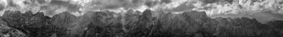
But here try to locate the Aufnahmestandort only approximately, do not aim at its name, because it is actually an unnamed summit, 5403 m according to the GPS, probably 25 m more due to GPS calibration issues.
The mountains of 8000 m recognizable inside here are three, but the most intriguing presence is maybe that of a certain mountain of 6993 m...
25 HF, Sony RX10 mk III, Zeiss Vario-Sonnar 24-600 at 70 mm equiv, f/5.6, 1/2000 sec.
Now reloaded with the DNG step suggested by HJBay, and Udeuschle-checked
Location: 28.69089 84.12247
Larger: https://bit.ly/2ZjFLAB
You find a wonderful labelling job at the bottom of the page
https://www.himalaya-info.org/kang_la.htm
Another large version: https://www.mountainpanoramas.com/___p/___p.html?panoid=2019_XA
Hans-Jürgen Bayer, Sebastian Becher, Alvise Bonaldo, Arno Bruckardt, Klaus Brückner, Hans-Jörg Bäuerle, Günter Diez, Friedemann Dittrich, Johannes Ha, Heinz Höra, Martin Kraus, Dieter Leimkötter, Wilfried Malz, Giuseppe Marzulli, Steffen Minack, Niels Müller-Warmuth, Jan Lindgaard Rasmussen, Danko Rihter, Werner Schelberger, Christoph Seger, Björn Sothmann, Michael Strasser, Konrad Sus, Jens Vischer, Benjamin Vogel, Augustin Werner
|
 |


Comments
VG, Danko.
Superb work.
I read your previous comment about your new Sony and Lightroom 5.x
I'm using also LR 5 and had the same issue with my small Fuji. What I did was using Adobe Raw Converter to convert the Raw files into the DNG Format and Imported them into LR5.
You'd keep the same features- It's only one more step to do.
Grandioso.
I have already performed some experiments with this solution.
The adjacent Gokyo panorama is now revised passing through the DNG format.
Giuseppe: sí, ero finito su per le montagne.
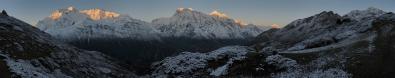
Lamjung Himal 0
Annapurna II 8.5 (8.5)
Annapurna IV 4 (12.5)
Annapurna III 10.5 (23)
Gangapurna 3.5 (26.5)
Roc Noir 9.5 (36)
Tilicho 9.5 (45.5)
Nilgiri 6.5 (52)
Leave a comment