
|
|||||
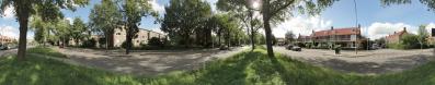
From the harbor of the Fishing Association you look out over the Noorderkolk of the Black Water.
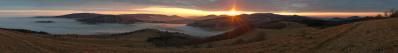
A beautiful rugged nature reserve with small islands, poplar avenues, willows and beaches. The large outer dike gulls here were created by sand extraction in the 60s. To the left of the bike is the Langenholterdijk that ends at the farm on my pano Langenholterdijk-Brinkhoekweg. To the right of my bike is the harbor of the fishing club with the Westerveldse forest behind it. This forest is now a recreational area with plenty of cycling and walking routes plus mountain bike trails. The park has been laid out on an old, landfill site about 20 meters high. In addition to countless different species of birds and insects, there are also roe deers. Until 1930 the area consisted mainly of meadows / dyke lands, flat low-lying soils along the Zwarte Water with grass and reeds. . In some parts of the site there are still some clearly visible traces that tell something about how this landscape originated. Canon G1X, 28 mm KB, 12 photos without a tripod. |
||||||||||||||||
|
|||||||


Comments
I would try to expose something darker. The sky is too bright left and right.
Leave a comment