Piana di Pisa   81710
vorheriges Panorama
nächstes Panorama
Details / LegendeDetails / Legende Marker ein / ausMarker ein / aus Übersicht ein / ausÜbersicht ein / aus   
 Durchlauf:   zum ersten Punkt zum vorherigen Punkt Durchlauf abbrechen
Durchlauf starten
Durchlauf anhalten
zum nächsten Punkt zum letzten Punkt
  verkleinern
 

Legende

1 Poggio Pelato, 378m
2 Monte Maggiore, 454m; 23,3Km
3 COLLINE LIVORNESI
4 Poggio Lecceta, 462m
5 Monte la Poggia, 364m
6 LIVORNO
7 Porto di Livorno
8 Punta Gorgona, 254m
9 ISOLA DI GORGONA
10 Punta Zirri, 213m
11 Arno
12 PISA
13 Duomo di Pisa
14 Torre Pendente (Leaning Tower of Pisa)
15 Battistero di Pisa
16 Monte Verrugoli, 749m
17 Chiesa di Santa Maria in Castello
18 House of Alberto (former)

Details

Aufnahmestandort: Torre di Caprona (Torre degli Upezzinghi)      Fotografiert von: Giuseppe Marzulli
Gebiet: Italy      Datum: 3 November 2018
SOLVED RIDDLE.

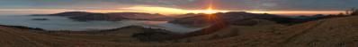
The "Piana di Pisa" is the plain of the final part of the Arno valley. It is the largest Italian alluvial plain after the Po Valley. The Pisan plain was formed by the floods of the Arno and Serchio, which in ancient times was a tributary of the first river.

It is hard to believe, but, by chance, I have photographed the house where Alberto lived for a few years.

Kommentare

Non lo so esattamente, ma una montagna lontana (con teatro) e un gruppo d'edificii con accesso per biglietto di prenotazione...ho visto le due (tre) questa primavera...
18.11.2018 22:08 , Klaus Föhl
Dentro la casona gialla nell'angolino in basso a destra io ho abitato per un certo tempo.
L'indirizzo è Via de Amicis 104, Arena-Metato.
18.11.2018 23:44 , Pedrotti Alberto
Incredibile. A farlo apposta non ci si riuscirebbe.
19.11.2018 00:57 , Giuseppe Marzulli
Se lo pubblicavi quattro giorni prima avrei anche aggiunto: potrei tornare a suonarci il 19 dicembre. Ora invece mi hanno detto di aver trovato un pianista piú a portata di mano. quindi al limite andrò come visitatore...
19.11.2018 01:08 , Pedrotti Alberto
@Klaus: non ho capito se hai capito.
19.11.2018 10:42 , Giuseppe Marzulli
I had some more time. Via C. C. leading out of the visible roundabout near C. gives me a second bearing. The first bearing is obvious. Openstreetmap gives me a candidate height of 145 m for you. But on the mountain in the distance I was wrong, I. d. G. is my guess now.
19.11.2018 14:39 , Klaus Föhl
Ok.
19.11.2018 20:14 , Giuseppe Marzulli
A very interesting panorama. I do not know if I would be able to do such a shot.
25.11.2018 23:07 , Christoph Seger

Kommentar schreiben


Giuseppe Marzulli

Weitere Panoramen

... in der Umgebung  
... aus den Top 100