Scheldt estuary at Breskens tele (completely reworked)   62542
vorheriges Panorama
nächstes Panorama
Himmelsrichtungen ein / ausHimmelsrichtungen ein / aus
Details / LegendeDetails / Legende Marker ein / ausMarker ein / aus Übersicht ein / ausÜbersicht ein / aus   
 Durchlauf:   zum ersten Punkt zum vorherigen Punkt Durchlauf abbrechen
Durchlauf starten
Durchlauf anhalten
zum nächsten Punkt zum letzten Punkt
  verkleinern
 

Legende

1 Lighthouse Breskens 1.5 km
2 North Sea
3 Lighthouse Westkapelle 15 km
4 Sometimes highest or second highest dune in the Netherlands near Zoutelande, 53 m high, 9 km and location of pano: 18039
5 Sardijn tower 85 m, 4 km
6 Vlissingen
7 Prisoners Tower 4 km
8 Church Lange Jan in Middelburg, 90 m high, 12 km
9 St James the Great Church medieval Vlissingen
10 Vlissingen harbor
11 Sloehaven port 10-11 km
12 Phased out nuclear power plant Borsele, 13 km
13 Ferry port Breskens
14  Church Ellewoutsdijk 19 km
15 Hoofdplaat, biggest plate in the river 5 up to 11 km
16 Cooling towers nuclear power plant Doel, Belgium, 51 km
17 Kloosterzande, Walsoorden, Ossenisse area, 30 -31 km
18 Cargo ship
19 Marina Breskens
20 Waterfront building Terneuzen, 22 km
21 Dow Chemical 18 km
22 Port Scalds apartments Breskens

Details

Aufnahmestandort: Breskens (8 m)      Fotografiert von: Mentor Depret
Gebiet: Netherlands      Datum: 10 July 2015
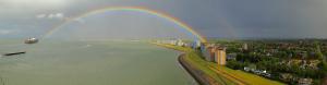
This is a tele version of pano 17916 and the 3th pano I ever made. However I didn't photograph in manual mode so a lot of very disturbing light transitions appeared on the first release. I corrected the pictures as good as I could and put them in the Hugin stitcher again. I am happy with the result right now reflecting the beauty and diversity of this location at the mouth of the river Scheldt, where the North Sea beach begins, with a nice view on the highest dunes (up to 53 m NAP) in the Netherlands near Zoutelande, Walcheren peninsula and on the Vlissingen sky line on a very beautiful day. Farthest objects are the twin cooling towers of Doel nuclear plant in Belgium, 51 km away.

CanonG1Xmark2, 29 pics, 81.25mm (155 mm KB), iso 200, f 10, from left to right: 1/640>1/500>1/400>1/500>1/640, stitched with Hugin.
I discovered that a 500 px height pano directly from Hugin yields an ugly result (which I did in the first release). So I made maximum possible with Hugin, did the downsizing in preview (Apple), corrected a few mismatches and then sharpened a bit. End result is 12097x499 px yielding same quality in Safari and Firefox.

Kommentare

Very exciting!
LG Jörg
24.08.2017 20:05 , Jörg Nitz
Hi Mentor. I have a curiosity. That series of poles that you see on the beach what they do?
24.08.2017 22:11 , Giuseppe Marzulli
Hi Giuseppe, these poles are needed to protect the beach from erosion. The tide difference is 4.5 to 5.5 m, two times a day, so currents are very strong and can wipe out the beach without protection. These poles break the currents and the waves.
24.08.2017 22:53 , Mentor Depret
Very interesting. A bit retouching of the front waves would improve the image without being so difficult.
26.08.2017 11:54 , Jörg Braukmann
Not my favorite holiday destination, but a very exciting documentation of your home region in fine quality!

Best regards, Hans-Jörg
27.08.2017 11:49 , Hans-Jörg Bäuerle
thx for the comments everybody, very appreciated.
27.08.2017 12:41 , Mentor Depret

Kommentar schreiben


Mentor Depret

Weitere Panoramen

... in der Umgebung  
... aus den Top 100