
| Cycle through labels: |
|
| Bric del Dente, 1107m |
| SP 73 (Strada del Passo del Faiallo) |
| Monte Pracaban, 946m |
| Monte Tobbio, 1092m |
| Monte Poggio, 1081m |
| Monte delle Figne, 1172m |
| Monte Antola, 1597m |
| Punta Martin, 1001m |
| Forte Diamante |
| Forte Fratello Minore |
| Forte Sperone |
| Forte Ratti |
| Forte Begato |
| Santuario Madonna del Gazzo |
| Monte Fasce, 834m (pano 20500) |
| A26 /Autostrada Genova Voltri - Gravellona Toce |
| Old Town |
| Porto Antico di Genova |
| Camogli |
| Vetta di Pegli |
| Monte di Portofino, 610m |
| A26 /Autostrada Genova Voltri - Gravellona Toce |
| Aeroporto Cristoforo Colombo (Genoa Airport) |
| Porto Commerciale di Genova (VTE) |
| Diga Foranea di Genova |
| Pra' |
| VTE |
| Voltri |
| Diga di Voltri |
| Monte Tardia di Levante, 878m |
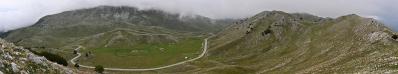
Genua aus dem Westen.
The pano was taken around the Faiallo Pass, at a distance of about 30 km from pano 20500, which should be compared. This pano shows Genoa and its valleys views from the west. |
||||||||||||||||
|
|||||||


Comments
How did they get the information for this excellent vantage points?
It is a scenic spot known in the area and reached by an easy walk of 10 minutes from Passo del Faiallo. The Passo del Faiallo is reached by car on a beautiful panoramic asphalted road. The road is well seen in this pano.
Tanti saluti, Hans-Jörg
For those not in a hurry and that goes for tourism it is certainly a fascinating highway.
Leave a comment