|
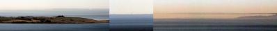
As discussed in the previous pano (#20213), Kinnekulle offers not only views beyond 100 km, but a total overview over the lake Vänern. If you have to choose one, and only one, location to watch the lake, this is the place.
The lake is of a size that is difficult to grasp. An old saga tells of Gefjon, a godess who was sent to Sweden, where she was allowed the land she could plough. She bred four sons with a Jætte (= Jotun = giant), and she turned them into oxes. The land ploughed was then dragged into the sea, and became Sjælland. Vänern came to be as a result. They nearly correspond in size and shape.
With a size of 5648 km², it is the 3rd largest lake in Europe. I hope you get a sense of that here. The farthest points are difficult to make out on this pano, but you will hopefully get an idea of distances presented anyway.
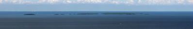
In the nearby surroundings, a few of the table mountains of Västergötland can be seen. Kinnekulle is also a table mountain. As can be seen at the nearby open pit mine, the lower parts of the landscape is sandstone. At some point, the eroding sandstone landscape had diabase pouring in some of the depressions, thus preventing further erosion. The sandstone around the diabase kept eroding, leaving the mesa-like tablemountains.
Otherwise, the landscape i quite low lying, which is why the huge lake sizes are prevalent in this part of Sweden.
Pano made from 29 pics (RAW), 50 mm, iso-100, f/8, 1/640 sec, developed in DPP (daylight, neutral, ALO off, moderate sharpness), stitched in PTGui pro, contrast adjustment, downscaling and sharpening in Irfanview.
Jörg Braukmann, Arno Bruckardt, Hans-Jörg Bäuerle, Friedemann Dittrich, Gerhard Eidenberger, Leonhard Huber, Walter Huber, Heinz Höra, Thomas Janeck, Wilfried Malz, Jörg Nitz, Danko Rihter
|
 |


Kommentare
Wieder ein sehr gut gemachtes Panorama, Jan. Es ist nicht nur, wie Du die Weite der Landschaft herausgearbeitet hast, sondern auch, wie Du sie mit den Wäldern eingerahmt hast.
LG Jörg
Kommentar schreiben