|
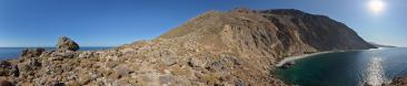
This is a companion to N.18683, which presented the north side. The standpoint lies maybe 50 m from the pass. On the stony flank above the bicycles you see (Panoramio) or imagine (500 pixel) the last line of prayer flags.
Far down, behind the switchbacks hosting the checkpoint of South Pullu (where we were not checked at all, since it was dinner time...), you see the Indus Valley, and you guess the town of Leh.
I already wrote in the twin panorama that the road from the Shyokh valley to Khardung La offers no less than 60 km of continuous ascent. Well, the descent to Leh is "only" 40 km, but it is all gravel of the quality visible here, also with several sandy stretches. That is why it was already dark when we entered the town. At last, we got also lost in a curious way that you can understand with N.19179 at hand. Namely, the hill hosting the Standort of that pano divides the upper Leh in two spikes. Our homestay was in the main one, namely, the green and lush one right below Khardung La. So, we assumed to live actually ON the road to Khardung La. Diversely, behind the Tsemo gompa the latter turns rather counter-intuitively towards the other half of the town. So, at 9pm of the last day of our seven-day Inner Line Permit we found ourselves seeking home in the total darkness of the upper town with the help of our GPS...
Larger: https://goo.gl/q5zgZu
GPS track: www.wikiloc.com/wikiloc/view.do?id=10746245
Hans-Jürgen Bayer, Daniel Buehler, Hans-Jörg Bäuerle, Friedemann Dittrich, Gerhard Eidenberger, Thomas Janeck, Martin Kraus, Giuseppe Marzulli, Steffen Minack, Jan Lindgaard Rasmussen, Arne Rönsch, Werner Schelberger, Wolfgang Schmähling, Jens Vischer
|
 |


Kommentare
How well can you acclimatize to these heights so that you can cycle all day?
Cheers, Martin
Kommentar schreiben