
| Cycle through labels: |
|
| Mavri Gourgoutha, 2435 |
| Melindaou, 2133 * |
| Rodopos, 738, 51 km |
| Diktymna, N.17494 |
| Pirou Limni, 2087 |
| Kefala, 2121 |
| Anthropolithos, 2098 |
| Katsiveli sources |
| Katsiveli refuge, 1950 |
| Mavri, 2070 |
| Modaki, 2225, N.7935 |
| Ornio, 2139 |
| Svourikhti NE * |
| Svourikhti, 2356 * |
| Agio Pneuma, 2254, N.18628 * |
| Bournelos, 2362 |
| Mesa Soros, 2345 * |
| Grias Soros, 2331, N.18201 |
| Askyfiotikos Soros, 2210 * |
| Sternes, 2335 * |
| (Roussies) |
| Kastro, 2219 |
| Kakovoli, 2214, N.18361 |
| Psiloritis, 2456, 68 km, N.17270 |
| Dochi, 2149 |
| Kedros, 1777 |
| Preveli, 41 km |
| Troharis, 2401, N.7018 * |
| Thodori Korfi, 2363 * |
| Kendakia, 2244 |
| Gavdos, 51 km |
| Exo Tourloti, 2221 * |
| Zaranokefala, 2099 * |
| Psiristra, 1935 * |
| Volakias SE, 2070 |
| Volakias, 2117 * |
| Gingilos, 1964 * |
| Psilafi, 1980 |
| (Samaria) |
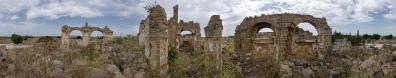
A 360° from the highest summit of the Lefka Ori.
Data according to the Anavasi map 1:25.000, "Lefka Ori" 32 HF, Canon G1X, 92 mm, f/5.6, 1/800 sec. www.panoramio.com/photo/128560663 |
||||||||||||||||
|
|||||||


Comments
www.wikiloc.com/wikiloc/imgServer.do?id=7398090
The current winter seems to be different, and poor of snow also there. Yesterday one of my Facebook friends made it to the summit without skis.
KR, Alberto.
Incidentally, the Lefka Ori mark my unique contribution to Geonames, since I entered the correct names of some major summits, which had been liberally scrambled. But I soon interrupted the job, when I was not able to enter the correct position of Kakovoli, only because the name had been previously "thrown" down somewhere on the flanks of the mountain.
I continuously got the appalling message "there is already one Kakovoli in the vicinity". Recall also that "kako" in Greek means nasty...
So, I decided that humanitarian jobs such as contributing geonames are suited only to rich and/or retired people - in one word, not to me.
And I returned to the old paper map!
Cheers, Alberto.
Leave a comment