|
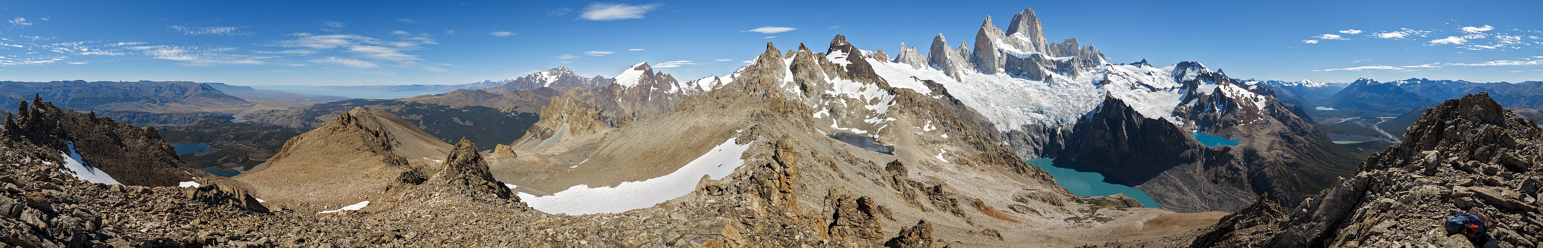
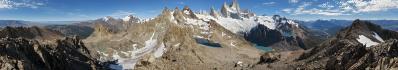
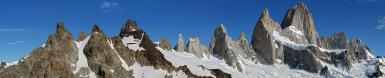
In my plans, this panorama should be the first of a series of 360° portraying the seven summits of the Fitzroy from seven different viewpoints.
Let me list these: I give their position imagining to sit on the very summit of the Fitzroy - a place where indeed few people did actually sit:
1: 002°, Paso del Cuadrado (1811 m)
2: 049°, Cerro Eléctrico (2155 m)
3: 087°, Cerro Madsen (1792 m)
4: 105°, Laguna de los Tres (1200 m)
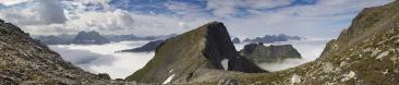
5: 125°, Loma de las Pizarras (1685 m)
6: 160°, Loma del Pliegue Tumbado (1490 m)
7: 182°, Saddle between Cerro Sólo and Cerro Grande (1750 m)
I would have material also from the "forbidden half" 180°-360°, but I think that, if I ever survive the first half without being banned from the site, it will not be the case to test the patience of the Betrachter any further.
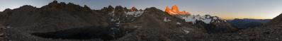
The curious thing is that, on the field, this view N.5 was born straight from N.3: namely, it was on the top of Cerro Madsen that I spotted a tiny lake high above Laguna Sucia, and short below the Loma. Snow covered, this lake is visible in the satellite image proposed by Google Maps. On the other hand, it is not to be found in any map; in my travel notes I referred it as Laguna Olvidada (forgotten lake), and my state of knowledge has not changed since then.
So, while descending from Cerro Madsen to the Poincenot camp, I was already formulated a new program for the following day. Instead of returning to El Chaltén via some well-established trekking path, I would reach Laguna Sucia, and from there explore the scree slope on its south side, in search for a passage to the newly-discovered lake. And indeed I found one, although not the simplest. My route passes through the "Little Red Summit" visible at 258°: a shoulder of a red peak of very broken rock that I believe to be Cerro Ñire. From there, I descended the thin snow couloir which is also in sight and... the lake was there, ready to host a bivac which would have been very fruitful from the photographic point of view.
In www.wikiloc.com/wikiloc/view.do?id=11013873 one finds both a better description of the route, and a basic (although for now largely incomplete) photo anthology.
My descent from the Loma followed its whole SSE ridge, which is the common trekking route, although there is an amazingly low number of people undertaking this ascent, perhaps because of its length. For example, in a day like the one shown here, I met only two people en route.
GPS track: https://www.wikiloc.com/wikiloc/view.do?id=11013873
Hans-Jürgen Bayer, Jörg Braukmann, Arno Bruckardt, Klaus Brückner, Hans-Jörg Bäuerle, Friedemann Dittrich, Klaus Föhl, Felix Gadomski, Johannes Ha, Johann Ilmberger, Thomas Janeck, Martin Kraus, Wilfried Malz, Giuseppe Marzulli, Steffen Minack, Jan Lindgaard Rasmussen, Danko Rihter, Patrick Runggaldier, Walter Schmidt, Björn Sothmann, Michael Strasser, Konrad Sus, Jens Vischer, Alexander Von Mackensen
|
 |


Comments
I'm curious, how long did the good weather window ?
Maybe you can mark a few distances ?
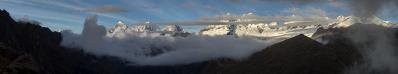
This said, that February was something that even the locals witnessed to have never seen before. I remember only three heavily cloudy / slightly rainy days, one at the Paso del Viento, another at the Glaciar Marconi, and the worst perhaps on the hidden side of the Fitzroy. If this series will go on, I will describe the experience in a future panorama. For now there is only a shorter one available: www.panoramio.com/photo/123939724
This said, this remains always Patagonia and not Marsa Alam. In January I did not have pitiful weather in the Paine, but one month before all the paths had been closed due to forbidding weather conditions.
Distances: I will do with Udeuschle, however Lago Viedma should be something like 70 km long. I remember this well since I reached El Chalten fully destroyed, after cycling 10 hours at 7 km/h in a furious headwind. Many other cyclists had stopped on the side of the road, waiting for better conditions.
Cheers, Alberto.
About distances: a short, an average and a long distance would be enough,
it's just for better understanding of the geography.
Steffen: now I have marked some distances.
Tanti saluti
Hans-Jörg
NB:
Alberto, is the altitude of Cerro Torre really correct - my informations are 3.128m in other guides 3.133m ?
- the book "Patagonia" By Metzeltin - Buscaini. Maybe you remember these names from an old panorama of the San Lorenzo;
- the Zagier and Urruty map of the region.
Maybe this has something to do with the point of considering or not the summit mushroom?
This could have relevance, like here in my region, where there are rumours that Cima Brenta has overtaken Cima Tosa, due to the snowcap on the top of the former having melted. The little difference is that I expect my GPS to prove or disprove one day this rumour, whereas I think that it will never have the luck to reach the summit of Cerro Torre!
If you search inside picasaweb.google.com/albertopedrotti/TorreFitzroy you find a telephoto allowing to estimate the summit mushroom. You find it short after an "enrosadira" on the Fitzroy.
This said, 26 metres are irrelevant with respect to the cartographic precision competing to this region. When creating renderings, more often than not I need to set Kamerahöhen of the order of 100 metres (for the Cerro Eléctrico, even more) to match the value given by the GPS.
Here at the Loma "only" 40 were needed, with Udeuschle at 1646, GPS at 1685, Buscaini at 1691 and Zagier at 1709.
Cheers, Alberto.
While searching for historical photographs, I came across your photos (attached), which could be very useful for my research.
I would like to kindly ask for your permission to use them in a scientific publication, with full credit to you as a photographer.
Thank you in advance for considering my request.
I look forward to your response,
Have a nice weekend
Regards,
Daniela Schmidt
Just write me an email at the address that you find in my profile, and I will send you the links to the albums on Google Photos, where you find the images in full size.
Have a nice weekend as well!
Alberto
Sorry to bother you, but I couldn´t find your email adress on your profile. I sent you a private message where I shared my email adress.
If you have a moment, I would really appreciate the chance to get in touch!!
Thank you very much,
Have a great week!
Daniela
when you are logged in, you will see an envelope in the panorama to the right of Alberto's name - click there, a menue opens and leave a message. Check the box at the bottom of the message to leave your e-mail address.
Greetings, Hans-Jörg
and thank you HJB.
Let us make things easier: I am on gmail.com, with the classical name followed by surname, don't bother about dots because Google by default skips them...
Nombre y appellido: mucho más simple que escalar el Fitz Roy.
(Puede ser: más simple tambien que subir a la Loma de las Pizarras!!!)
Greetings,
Alberto.
Leave a comment