Between two countries   144515
previous panorama
next panorama
Details / LabelsDetails / Labels Markers on / offMarkers on / off   
 Cycle through labels:   first previous stop
play
pause
next last
  zoom in
 

Labels

1 Maja e Rops - 2502 m
2 Djeravica - 2656 m
3 KOSOVO
4 Podgoje - 2119 m
5 Ocnijak - 2185 m
6 Volusnica - 1879 m
7 Kolata - 2528 m
8 Karanfil Ljuljasevica - 2290 m
9 Gvozdeni vrh
10 Severni Karanfil - 2460 m
11 Velki Karanfil - 2490 m
12 Juznji Karanfil - 2441 m
13 Ropojanska Vrata
14 Maja Scokistes - 2396 m
15 Maja Fortit - 2340 m
16 MONTENEGRO
17 Maja Vukoces - 2450 m
18 Maja Ellat - 2275 m
19 Maja Peje
20 Maja Vojusa - 2210 m
21 Maja Preht - 2466 m
22 Maja Lagovjet - 2466 m
23 Popadija - 2057 m
24 Maja Nigvacit - 2412 m
25 ALBANIA
26 Maja Shnikut - 2554 m
27 Kapa e Brojes - 1981 m
28 Berisdol - 1981 m
29 Mridzi - 1953 m
30 Golisit - 2023 m
31 Surdup

Details

Location: Popadija (2057 m)      by: Konrad Sus
Area: Albania      Date: 10.07.2012
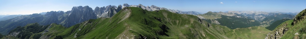
Hot summer day at ridge of Popadija. Its very good sight point to western part of Prokletije (Damned Mountains). Popadija is two summit mount with the same elevation, located at border Montenegro/Albania. In my opinion, nicest view is to Karanfili (Karanfili means cloves) range above beautiful Grbaja Valley.
Its not easy to find trail. Great feeling, when you are alone and everywhere around are unknown mountains.

Comments

Very nice view at this borderline of the two countries. Technically I like it much. Crisp sharpness without excessive tonal value changes leaves (makes) it pretty natural. VG HJ.
2014/01/25 21:56 , Hans-Jürgen Bayer
Re: 
Thanks. As you notices, this photo is almost no - edited. When I tried to darkening the sky, colors were too blue for me. I let them, like it is. Problem was with sun on right side.
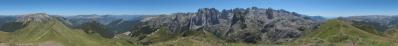
BTW -Today I discovered udeuschle, I didn`t know, that is exist site like this. But in Albania - Montenegro there`s so much errors. I must to be careful in labeling of summits.
2014/01/25 22:15 , Konrad Sus
A really good pano. I like the natural colors and perfect sharpness - no need at all for editing. Thanks for labelling all the peaks - it would be really interesting if you could also tell something about the area and your technique in the "Description". Cheers, Martin
2014/01/25 22:50 , Martin Kraus
Well labeled and preseted landscape. It would be interesting if you add some elevation and orientation. IMHO the horizon is correct here.
2014/01/25 22:53 , Jörg Braukmann
Horizon, colours and sharpness are really very good! I agree with Jörg Braukmann. Some elevations would be fine.
LG Jörg
2014/01/26 11:25 , Jörg Nitz
Re: 
Until now, I described the panoramas of my knowledge and maps. Now, it will be easier to me.
2014/01/26 13:31 , Konrad Sus
Wonderful Konrad, i like this view!!! Kind regards, Hans-Jörg
2014/01/26 22:07 , Hans-Jörg Bäuerle
Beautiful landscape, the grassmountains in the foreground are similar to those in the Allgäu. LG Fried
2014/01/26 23:15 , Friedemann Dittrich
Great!!
2014/01/27 17:09 , Sebastian Becher
nice panorama Konrad. Btw you can improve the udeuschle.de results by registering on geonames.org. You can create or update important land marks in the map client on this site. udeuschle.de retrieves all nonalpine summit infos (name, elevation) from this domain.
Kind regards, Matthias.
2014/01/29 23:49 , Matthias Stoffels
A wonderful bucholic place with a harsh background!
Pleased to know that the Prokletije topography remains a challenge even for you, even if you seem to be very well informed on the subject.
My personal difficulties are explained in detail in 13825 and 14133.
In the description of the latter you find also a link to a Panoramio work dedicated to the exploitation of the puzzling imprecisions of Udeuschle in well-delimited places of this border region, the Karanfili being the most outstanding victim.
Throughout the comments to the Prokletije panoramas you also find precious contributions by Heinz H. about sharing knowledge of topographical names.
Greetings, Alberto.
2014/02/02 15:00 , Pedrotti Alberto
Re: 
Yes, I wrote about problems of description below your panoramas. My knowledge about summits is thanks to summitpost friends and from maps.
I have a little correction of Your panorama - Maja Karanfili.
Cheers
Konrad
2014/02/02 16:47 , Konrad Sus
Yes, it is enjoyable for me to compare the Karanfili seen from two opposite sides.
A question: Did I understand well if I say that the pass in direction NW is the Qafa Perdolec, with Lepushë hidden a bit underneath, such that the background in www.panoramio.com/photo/98451514 is precisely your mountain?
Greetings, Alberto.
2014/02/03 16:09 , Pedrotti Alberto
Re: 
I think it is, Popadija is two summits mount - like on Your picture. On of summit - I think to left at photo - named Talianka. I not sure about information, because i have it from local shepherd, I met at border.
2014/02/06 10:15 , Konrad Sus

Leave a comment


Konrad Sus

Portfolio

More panoramas

... in the vicinity  
... in the top 100