
| Cycle through labels: |
|
| Sangenberg 566 m, 27 km |
| Herzberg 633 m, 16 km |
| Reesberg 291 m, 46 km |
| Diabas quarry, 9 km |
| Rammelsberg 635 m, 16 km |
| Brautstein 648 m, 14 km |
| Gelmkeberg 601 m, 14 km |
| Okertal |
| Breitenberg 624 m, 9 km |
| Röhrtanz 623 m, 11 km |
| Goslar, 20 km |
| Adenberg 536 m, 13 km |
| Gabbro quarry, 8 km |
| Langer Berg 254 m, Innerstebergland, 44 km |
| Winterberg 585 m, 7 km |
| Kleiner Brocken 1019 m, 1 km |
| Salzgitter Höhenzug 329 m, 20-38 km |
| Ettersberg 500 m, 8 km |
| Bad Harzburg, 11 km |
| Kleiner Burgberg 478 m, 8 km |
| Sachsenberg 546 m, 8 km |
| Harly, 20 km |
| Scharfensteinklippe 672 m, 4 km |
| Hermannsklippe 749 m, 2 km |
| Kaltetalskopf 600 m, 7 km |
| Giersköpfe 595 m, 5 km |
| Mittelberg 590 m, 9 km |
| Taubenklippe 572 m, 6 km |
| Woldsberg 569 m, 9 km |
| Eckertal |
| Maizenkopf 572 m, 6 km |
| Zwisselkopf 585 m, 7 km |
| Elm 323 m, 44 km |
| Stapelburg, 11 km |
| Grosser Fallstein 288 m, 25 km |
| Rohnberg 564 m, 5 km |
| Elm |
| Meineberg 545 m, 6 km |
| Ilsetal |
| Ilsenburg, 8 km |
| Stumpfrücken 561 m, 6 km |
| Blocksberg 622 m, 4 km |
| Pfortenberg 686 m, 4 km |
| Halberstädter Berg 571 m, 7 km |
| Moosklippe 555 m, 5 km |
| Tänntal |
| Huy 314 m, 33 km |
| Weisse Steine 710, 4 km |
| Wolfsklippen 723 m, 4 km |
| Sonnenklippe 750 m, 3,7 km |
| Meineberg 575 m, 6 km |
| Darlingerode, 10 km |
| Sandtal |
| Grosser Jägerkopf 746 m, 3,9 km |
| Pahnberg 533 m, 8 km |
| Kakemieke 339 m, 10 km |
| Wernigerode, 12 km |
| Bielstein 528 m, 7 km |
| Agnesberg 378 m, 13 km |
| Agnesberg 378 m, 13 km |
| Wolfstor 533 m, 6 km |
| Kapitelsberg 402 m, 10 km |
| Hakel 244 m, 50 km |
| Drängetal |
| Fenstermachenberg 466 m, 15 km |
| Armeleuteberg 478 m, 11 km |
| Beerberg 450 m, 7 km |
| Nackenberg 395 m, 19 km |
| Hilmersberg 508 m, 11 km |
| Vorderer Voigtstiegberg 463 m, 13 km |
| Staufenberg 433 m, 21 km |
| Wellbornskopf 555 m, 10 km |
| Mailauben Kopf 573 m, 31 km |
| Hohnekamm 908 m, 5 km |
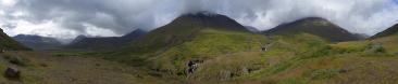
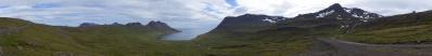
A more undisturbed northern tiefblick (don't know an English word) from Brocken, in addition to the Brockenpano #13809. The lowland lies at appr. 150 m, and rises to appr. 500 m in the first "wave" of the Harz-wall. The northern part of the Harz, Oberharz, is characterised by long, narrow and winding valleys. They very much contribute to the charm of the Harz, and some can be seen here.
To stand as high as possible it was shot around the Brockenhaus, hence the corner at the beginning. The composition of the pano, with the Wetterwarte at the end, could be reworked. The pano could also end at the Brockenbahnhof. We'll see... The pano made from 15 pics (RAW), iso-100, 1/400 sek, f/8, 50 mm, developed in DPP, stitched in PTgui, minor contrastwork in GIMP, re-scaling and sharpening in IrfanView. Labels in a little while... |
||||||||||||||||
|
|||||||


Comments
Von der Komposition her, ist das Panorama m. E. nach sehr gut gemacht, farblich und was die Kontraste betrifft auch. Am meisten habe ich mich über die Beschriftung gewundert. Die ist ja noch detaillierter als bei Deinen Heimat-Panoramen, Jan. Ich finde alles bezeichnet, was ich aus der Zeit, als wir öfter im Nordharz unterwegs waren, kenne, und sehe noch viel mehr, was ich noch nicht kannte.
Warum man in den Kommentaren immer direkte Vergleiche mit Namensnennung lesen muss erschliesst sich mir gerade nicht. Auch das angesprochene 5682 gefällt.
Bei Deiner Bearbeitungsqualität merke ich, dass ich oft frühzeitig meine Arbeiten in den Papierkorb geworfen habe!
Gruss Walter
@Hans-Jürgen, die 224km sind auf meinem Pano vom Fichtelberg zum Brocken zu sehen, bei sehr mäßiger Qualität, aber zweifelsfrei. Ist aber wirklich extrem selten. Ich habe voriges Jahr mit dem Wetterwart vom Fichtelberg gesprochen. Der wohnt dort oben und hatte bis dahin den Brocken auch erst dreimal gesehen. Das immerhin bis zu 200km entfernte Riesengebirge ist dagen von dort etwas öfter zu sehen. LG Fried
Hab mich mal gefragt, ob man vom Brocken bis nach Hannover sehen kann...?!
@Christian: It will probably be better to watch the other way round, from Hannover to Brocken, but it must be possible. The distance is 85 km, and Brocken can "see" a sea horizon at 120 km. LG Jan.
I like this picture very much. Sometimes, the landscape is not in boosting strong colours, this gentle, more "pastellfarbenartige Stimmungen" are much harder to grasp.
Just to share ideas: Working with the Graduationskurve is in my eyes always a very good idea, as long as it is not misuesed to boost the picture to a contrast which was not there. Reducing red is - to my opinion, which is following an adivse by HJB1 - always necessary, since there is (at least in gimp) a red-shift when you do the compression of the picture. Only rcently I did add the "lichter/tiefen" tool in PS for pictures with strong shadow parts. If I do not need it, most of the correction is done with the graduation curve in gimp.
Herzlichst Christoph
PS: Maybe you can replace the wall at the leftmost pixel rows with something more natural ...
Sorry for the late reaction...I hope you can accept the corner to the left. Then one knows why it doesn't start further left.
Also, thank you for the colour explanation. Interesting with the increasing red in compression, and contrast work. LG Jan.
Leave a comment