|
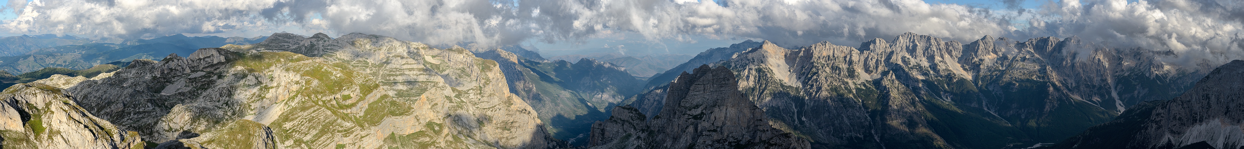
I have at least a little bit of luck with this picture: Being the owner, I do not have to rate it, which would be really a problem, because the more I look at it, the more I realize that I do not know if I appreciate it or not.
Aesthetically, I only like to scroll the upper right, "Dolomitic" region, in the larger version, linked below, but here I prefer to show the whole image, for the sake of information, and not least to use the labeling facility as soon as I understand something... Namely, up to now I have understood very little. The Udeuschle rendering is very unreliable in the Prokletije, starting from the very height of the summit, which instead of the 2525 metres on which the maps and my GPS agree, is rated 2492 metres. But even the shapes of the mountains are highly unreliable - which aspect becomes even more evident in the part of the 360° which is not shown here - if you create the 360° rendering, find out what happens, for example, at 265°!!
As for the names of the mountains, the various sources, including Udeuschle itself and the apparently well-informed Summitpost, are more often than not in disagreement.
If two years before in the triple point Mongolia-Russia-China I had found minor discrepancies between reality and rendering (see the discussion in N.9762), in this apparently less exotic triple point Montenegro-Kosovo-Albania the topographical problems appear to be much harder!
Hope to understand something and to change the present lines accordingly in the near future.
Whoever knows, is begged to help!
Fernsicht-remark: the Udeuschle theoretical maximum distance lies in Bulgaria, Rila mountains, above the Rila lakes (see N. 13238), 283 km far from here.
17 vertical images, 70 mm (x 1.5), 1/320 sec, f/10.
Larger: goo.gl/qr6DyW
GPS track: www.wikiloc.com/wikiloc/view.do?id=5582913
Hans-Jürgen Bayer, Sebastian Becher, Peter Brandt, Hans-Jörg Bäuerle, Hans Diter, Friedemann Dittrich, Heinz Höra, Thomas Janeck, Martin Kraus, Wilfried Malz, Giuseppe Marzulli, Jan Lindgaard Rasmussen, Danko Rihter, Arne Rönsch, Markus Schwendimann, Christoph Seger, Matthias Stoffels, Michael Strasser, Jens Vischer, Augustin Werner
|
 |


Kommentare
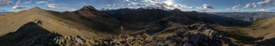
Yes, I agree that the scenery is indeed a first-class one - to this aim, check the enthusiastic title that I chose on Panoramio. Why I am not fully satisfied, is hard to explain. Let me try: the particular lighting condition enhances the fight between the different greens of the two sides. In the reality, I did not perceive the difference to such an extent - maybe simply because I had to turn my head around meanwhile or, maybe, because I enjoyed the huge amount of sun that you see (...) only for few seconds. So, the disappointment comes only from the image betraying my memory; who was not there, of course, can neither feel, nor understand such a paranoia!!
Cheers, Danko.
However, it is true that in the Prokletije I found no more than three other tourists in action. They were three young Polish mountaineers from Stettin and, curiously enough, we discovered to have a common friend, namely, another girl from Stettin whom I got to know in 2007 on the Ortles-Cevedale and that, few weeks later, I visited in Osnabrück, where she studied at the time. This originated the cycling stage Osnabrück-Brocken of which we were speaking few days ago... and also proves that the world is, under certain respects, somewhat small!
Incidentally, two days after the Prokletije, I was on the Lovcen in Montenegro. There I intersected the trajectory that I followed in 2003 cycling from the Brocken to Peloponnese... yes, these strange mountains definitely seem to bear some strange relationship with the Brocken!
PS: I see after completing the scrolling that you also use IrfanView ;-)
P.S.: what we pointed out in N.12709 remains indeed true. However, I find amazing to see how a general-purpose tool (as is IrfanView with respect to sharpening, without any slider to drag) can display such a good average performance, yet allowing people to save time - a resource which I rate far more precious than sharpness!
Regarding udeuschle: As far as I got it, he is using map models available to him. Geopolitical thinking it does not astonish me, that the Mongolian / Russian border region is better mapped than the remote southwest Balkan.
Regarding Irfan Skiljan: Thank you very much for pointing out his background. What a fascinating story! pp can be quite educating!
Herzlichst Christoph
Christoph, ich konnte keine fasziniernde Story entdecken. Liegt vielleicht daran, daß ich kein "Westerner" bin.
LGC
Kommentar schreiben