
| Cycle through labels: |
|
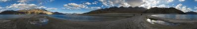
| Naracauli |
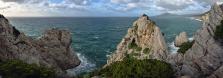
| Piscinas |
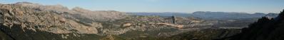
Nella descrizione del mio precedente panorama ho citato Guido Piovene e il suo «Viaggio in Italia». Attingendo dalla medesima fonte:
«L'Italia, nel suo insieme, è una specie di prisma, nel quale sembrano riflettersi tutti i paesaggi della terra, facendo atto di presenza in proporzioni moderate e armonizzandosi l'un l'altro. L'Italia, con i suoi paesaggi, è un distillato del mondo». (pag. 394 dell'edizione originale Mondadori, settembre 1957) Cosí in Italia non manca nemmeno una rappresentanza del deserto. Le dune di Piscinas raggiungono talora un'altezza apprezzabile, dell'ordine di 10-20 metri. In the description of my previous panorama I quoted Guido Piovene, and his «Viaggio in Italia». In the same book, we read: «Italy, considered altogether, is a kind of prism, which seems to reflect all the landscapes of Earth: they seem to put in an appearance in moderate proportions, thus establishing harmony among themselves. Italy, with its landscapes, is a kind of distillate of the world» This image shows that in Italy even the desert is somehow represented. |
||||||||||||||||
|
|||||||


Comments
Herzlichst Christoph
I wondered why the object happened to lie in Nigeria and not in the usual surroundings of the Gulf of Aden...
Now it seems to work- fun to check, by the way, how many panoramic shipwrecks there are in the Red Sea!
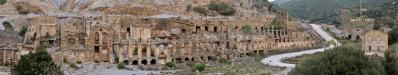
Yes, the "abandoned shoes", as well as the "shallow shadow" at the other end of the image were intended as part of the composition - I thought that they could help to convey the sense of "abandonedness" of the place under the indifferent winter light.
But since this was a totally GPS-recorded tour, I wanted to convey the precise data coming from the instrument. Actually, when - after the correction requested by C. S. - I checked the location on Google Maps, I was even able to recognize the bushes!!
The history of my GPS is rather strange. I bought it in 2010 not to locate photos/bushes, but to potentially save my life in the Pamir. Surprisingly enough, when I first went to climb Pik Korjenevskaya, I left it at the base camp... The peak is 7105 m high, and I had to turn back at 7000 since I was alone and a snowstorm was deleting my footprints (http://www.panoramio.com/photo/78255620).
Few days later I was engaged in another attempt on Korjenevskaya, but the GPS was still, incredibly, at the base camp. Latins said «errare humanum, perseverare diabolicum»... At 7050 I was again in a snowstorm, and again alone, since my companion had done even worse, leaving down her North Face orange suit (ibidem, 78255489). So, she had already turned back little after Camp 6300 - the one of some panoramas. Luckily, while I was waiting, all bent like a wheel or like a sleeping dog, I saw two people materializing from within the storm... they were two climbers from Bulgaria, and they had the instrument with them. So they "guided" me safely to the summit, and back down!
The following year in Mongolia I had the GPS working all the time, that is for one month. Alas, with a little but notable exception: The five days that we spent on a horse riding around in the Tsaatan land I had forgotten it at the departure place. Now, on January 6, 2013, when I came back from Sardinia and I first opened my email, I found one message waiting, where scholars from the Oxford University informed me that they are organizing a research expedition to the Tsaatan taiga. They asked me to gently supply them my GPS tracks... And so, I had to tell them the truth, how the GPS those days was resting in a forgotten bag, and how my Panoramio photos were located only approximately, with the help of Google Earth. So, now they are asking me if at least I can help them giving the permission to use my photos/panoramas in their web pages and applications for grants.
This is the brief history of my GPS... So you understand: I make it work at Piscinas since I never made it work when it was the time!!
Leave a comment