
| Durchlauf: |
|
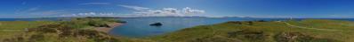
| Traeth Llanddwyn (Llanddwyn Strand) |
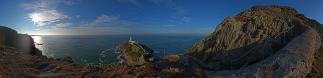
| Elidir Fawr (924m) |
| Y Garn (947m) |
| Glyder Fawr (999m) |
| Crib y Ddysgl (1065m) |
| Snowdon - Yr Wyddfa (1085m) |
| Mynydd Mawr (698m) |
| Trum y Ddysgl (709m) |
| Craig Cwm Silyn (734m) |
| Garnedd-goch (700m) |
| Mynydd Graig Goch (610m) |
| Bwlch Mawr (509m) |
| Gyrn Ddu (522) |
| Yr Eifl (564m) |
| Twr Mawr (transl. grosser Turm) |
| Pen-y-parc |
| Traeth Penrhos (Penrhos Strand) |
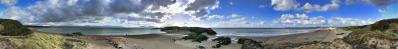
Noch mal 5221 nur dieses Mal mit Herbstsonne, weniger Farbwechsel und hoffentlich ohne Delle im Meer.
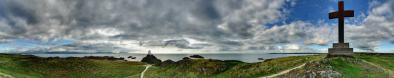
Dieses Bild zeigt Newborough beach mit der Landzunge (Llanddwyn Island). Der Strand zur rechten wie zur linken erstreckt sich etwas mehr als eine Meile. Im Hintergrund sind die Berge von Snowdonia (zur linken) und der Llyn Peninsula(bei Llanddwyn Island) zu sehen. Seit letztem Samstag (6.11) gibt es die Berg Gipfel auch wieder mit Schnee.
Gefällt
8 Mal
|
||||||||||||||||
|
|||||||


Kommentare
Habe die Sachen bisher immer von Hand mit Karte und so gemacht. Aber fuer so entferntere "Huegel" ist die web site sehr hilfreich!!!
Hier noch was uber den Wald (von http://www.bbc.co.uk/wales/northwest/sites/walks/pages/newborough.shtml )
The sand dunes around this area are also known as being the largest in Wales and arguably one of the finest in Europe. From here the route takes you through the forest which is now managed by Forest Enterprise Wales. The forest was planted after World War II as part of a Government move to provide the country with as much timber as possible in case the country went into war again.
At the same time, the new forest provided employment for the troops returning to Anglesey and helped to prevent the movement of sand and sand dunes onto the road and village of Newborough. Today, the forest covers acres, and is home to squirrels, bats and a successful raven roost.
Kommentar schreiben