
| Durchlauf: |
|
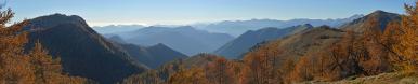
| Monte Rosso, 2374m |
| Punta della Barma, 2379m |
| Monte Camino, 2388m |
| Monte Tovo, 2229m |
| Monte Pietra Bianca, 2490m |
| Monte Cresto, 2542m |
| Monte Nery, 3075m |
| Corno Maria, 2766m |
| Punta Caparelli, 2411m |
| Punta Serange, 2333m |
| Monte Gemelli, 2472m |
| Punta Tre Vescovi, 2500m |
| Monte Marca, 1614m |
| Cima di Bo, 2555m |
| Rocca dell'Argimonia, 1613m |
| Punta del Cortese, 2707m |
| Punta di Rissuolo, 3102m |
| Punta di Ciampono. 3233m |
| Corno Bianco, 3320m |
| Corno di Puio, 3031m |
| Gobba di Rolin, 3899m |
| CERVINO (MATTERHORN), 4477m |
| Punta Straling, 3115m |
| Punta Castore (Castor), 4228m |
| Naso del Liskamm, 4272m |
| Liskamm Occidentale, 4479m |
| Liskamm, 4527m |
| Pyramide Vincent, 4215m |
| Cima di Scoperta, 4335m |
| Punta Giordani, 4046m |
| Corno Nero, 4321m |
| Ludwigshöhe, 4341 |
| Cima di Bors, 1959m |
| Punta Parrot (Parrotspitze), 4432m |
| Capanna Margherita/Punta Gnifetti,/Signalkuppe, 4554m |
| Punta Dufour (Dufourspitze), 4634m |
| Nordend, 4609m |
| Monte Tagliaferro, 2964m |
| Jägerhorn, 3960m |
| Punta Grober, 3497m |
| Monte Barone, 2044m |
| Weissgrat, 3659m |
| Cima di Jazzi, 3803m |
| Neue Weisstorspitze, 3639m |
| Adlerhorn, 3988m |
| Rimpfischhorn, 4199m |
| Strahlhorn, 4190m |
| Täschhorn, 4491m |
| Allalinhorn, 4020m |
| Dom, 4545m |
| Lenzspitze, 4294m |
| Ulrichshorn, 3925m |
| Castello di Gavala, 1827m |
| Spechhorn, 3189m |
| Stellihorn, 3436m |
| Jazzihorn, 3227m |
| Almagellhorn, 3327m |
| Bec d'Ovaga, 1638m |
| Latelhorn, 3204m |
| Augstkummenhorn, 3419m |
| Pizzo del Moro, 2335m |
| Sonnighorn, 3487m |
| Rottalhorn, 3815m |
| Weissmies, 4023m |
| Pizzo di Andolla, 3653m |
| Lagginhorn, 4010m |
| Fletschhorn, 3993m |
| Tossenhorn, 3225m |
| Cima di Forno, 2241m |
| Cima Cresta, 2324m |
| Cima di Razzarola, 1714m |
| Cima Altemberg, 2394m |
| Cima di Capezzone, 2421m |
| Monte Capio, 2172m |
| Monte Ronda, 2416m |
| Monte Forcolaccia, 2034m |
The A26 (Genoa-Gravellona Toce highway), in case of excellent visibility, offers remarkable views of Monte Rosa. The obvious challenge is finding a safe stop without encountering obstacles. There was a small lay-by here, and I was able to pull over safely.
Gefällt
18 Mal
|
||||||||||||||||
|
|||||||


Kommentare
Yesterday Jörg N. showed us Matterhorn/Cervinio from Ballon d'Alsace, today it's you with a shot from an Italian autostrada.
And, yet, nobody can complain that those panoramics better should be shown at alpen-panoramane.de.
Great work by the two of you.
LG Jörg
Grandios ist Licht gesetzt hast du das Signalhorn. Danke für die umfangreiche Beschriftung.
Der Mittelgrund könnte in meinen Augen etwas besser entrauscht sein. Liegt das an einer zu starken Aufhellung der Tiefen?
Grüße,
Dieter
I use post-production software as little as possible, also because I don't know how to use it well.
Obviously I could learn, but I've decided that when I stop traveling (hopefully as late as possible) I'll dedicate myself to post-production software, reworking all the panoramas.
My enjoyment is seeking out new vantage points or vantage points I've never seen. Everything else, for me, is secondary.
Kommentar schreiben