|
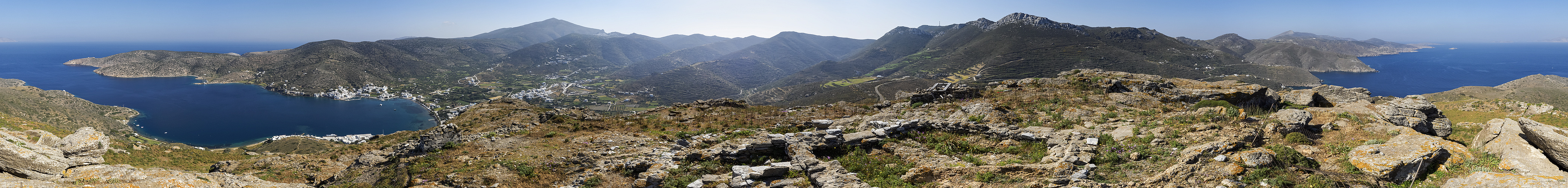
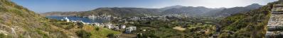
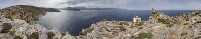
Das erste offensichtliche Ziel im Aufstieg vom Hafenort Katapola ist der oberhalb gelegene Hügel mit den Ruinen der alten Siedlung Minoa, die in klassischer Zeit (und darüber hinaus) vom 11. Jh v. Chr, bis zum 4. Jh n. Chr. das Zentrum der Insel war. Ein Fahrweg führt zur Ausgrabung, dort ist aber nichts erschlossen, und man muss sich etwas mühsam den Weg zum höchsten Punkt suchen. Oben wird man nicht nur mit alten Mauern, sondern auch mit einer Rundsicht belohnt.
The first obvious destination in the ascent from the harbour town of Katapola is the hill above with the ruins of the ancient settlement of Minoa, which was the centre of the island in classical times (and beyond) from the 11th century BC to the 4th century AD. A dirt road leads to the excavation, but there is no development and you have to find your way to the highest point with some effort. There, however, one is rewarded not only with old walls, but also with a wide view.
Olympus OM-D E-M5 III
M.Zuiko 12-45/4.0 Pro @12mm (=24mm KB)
51 HF RAW freihand in 3 Reihen mit Crop, ISO 200, 1/1000, f8
Lightroom Classic CC, Autopano Giga 4.4.2, IrfanView
360° Blickwinkel
Direktlink auf Google Maps: https://goo.gl/maps/R5g98TzkkC7BAH4U9
Hans-Jürgen Bayer, Müller Björn, Peter Brandt, Jörg Braukmann, Klaus Brückner, Hans-Jörg Bäuerle, Heinz Höra, Dieter Leimkötter, Wilfried Malz, Giuseppe Marzulli, Matthias Matthey, Steffen Minack, Jörg Nitz, Jan Lindgaard Rasmussen, Danko Rihter, Arne Rönsch, Silas S, Björn Sothmann, Konrad Sus, Arjan Veldhuis, Jens Vischer, Augustin Werner
|
 |


Kommentare
Herzliche Grüße
Hans-Jörg
LG Jörg
Kommentar schreiben