|
There are three main road crossings of the Cordillera Blanca. From north to south, first comes the Lllanganuco (N.26027), scenically by far the best. Next comes Punta Olimpica (N.27578), the highest one, at 4890 m, although now bypassed by a tunnel at 4730 m. Last comes the Cahuish, in the southern half, featuring a tunnel at 4450 m: unlike the Olimpica, here the crossing would not be feasible without the tunnel. South of the Cahuish the main Cordillera peters out, so to say, into the Conococha plateau (N.28835). But an eastern branch, although not featuring major summits, remains high, blending at Abra Yanashalla with what some maps mark as a short Cordillera Huallanca, interrupted south orthogonally by the Cordillera Huayhuash. It is named after Huallanca, the only moderately big town in the Huayhuash region, lying almost at the border between the regions of Ancash and Huanuco, and not to be confused with a Huallanca in the northern Ancash, which marks the beginning of the famous Canyon del Pato.
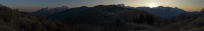
Before Conococha, the main Cordillera features a last outburst of 5400-5500 m summits, among which Nevado Pastoruri, although a minor summit, is by far the most known, because of the famous retreating glacier (N.28945) which is used as a benchmark of climatic change. North of the Pastoruri there is the wide Abra Huarapasca, 4780 m, which is connected to Yanashalla by a long winding gravel road, which is one of the most pleasant and panoramic stretches of the region.
The road is almost flat, although with some sudden steep stretches. When I returned from the ridge to the bicycle after shooting the present panorama, I saw the arrival of a couple from Leipzig, who where pushing their bicycles up one such stretch. They were completing their second year cycling around the world, and it was my pleasure to show them in the background the towering Yerupajá and the whole Huayuash, of whose existence they did not know, since they claimed to have used no map after leaving Europe.
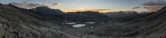
More modestly, I was completing my second month, during which I had seen no other cyclist (!!) until the previous evening, when I met a Swiss guy short below Yanashalla. Abra Yahashalla (in turn not to be confused with another 4700 m Yanashalla, Yanashallash on Alpenverein, located between Huantsan and Cahuish) here is hidden, but can be guessed left of the summit at 126° which dominates it.
Besides Yerupajá, the present 360° encompasses also another giant, namely the Huantsán, which at 6395 m is by far the highest mountain of the southern half of the Cordillera. Unfortunately, the clouds wrapped him right before I reached the ridge.
The unnamed summit marked at 4° lies little north of Antamina, one of the largest mining sites of the continent. From Huallanca, an asphalted road forks to Antamina short below Yanashalla: it is mandatory to follow it at least until the Huellas de Dinosaurio, mysterious gigantic footprints visible on the side of the road at two different spots. The huellas lie right behind the little ridge visible at 40°-55°.
Location: -9.835779 -77.112559
Larger: https://bit.ly/3imoWzP
Hans-Jörg Bäuerle, Günter Diez, Friedemann Dittrich, Johannes Ha, Leonhard Huber, Martin Kraus, Dieter Leimkötter, Wilfried Malz, Giuseppe Marzulli, Werner Maurer, Steffen Minack, Jan Lindgaard Rasmussen, Danko Rihter, Björn Sothmann, Arjan Veldhuis, Jens Vischer, Benjamin Vogel, Augustin Werner
|
 |


Kommentare
Kommentar schreiben