
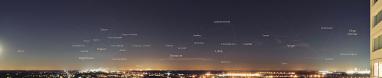
| Durchlauf: |
|
| Rug van Baarland plate, 9 - 11 km |
| Middle plate, 3 km |
| St-Gummarus Church (faintly visible), village of Steenbergen, North-Brabant, 43.5 km |
| Grote Onze-Lieve-Vrouwe church, village of Tholen, 34.3 km |
| Houses near former Kruiningen car ferry port, 17.7 km |
| Big Ossenisse plate, 13 - 15 km |
| Theodorus Harbor Bergen-op-Zoom, 34-35 km |
| Cargill Theodorus Harbor Bergen-op-Zoom, 34.9 km |
| Industry Theodorus harbor Bergen-op-Zoom, 34.3 km |
| St-Gertrudis Church, center city of Bergen-op-Zoom, North-Brabant, 36 km |
| New apartment building on Bergse Plaat, Bergen-op-Zoom, 34.1 km |
| Apartments Groeshof, Bergen-op-Zoom, 37.3 km |
| Radar near Waarde, 18.1 km |
| Small harbor of Griete, 3.7 km |
| Holy Martinus Church, village of Kloosterzande, 12.7 km |
| Radar Saeftinghe, 25.7 km |
| Ridge of about 25 to 30 m height called Brabant Wal or Zoom marking the beginning of heather landscape continuing into Belgium as Kalmthoutse heide, 35 km |
| BASF Antwerp Harbor (B), 29.5 - 30.9 km |
| Noorderkaai container terminal Antwerp Harbor, 29.3 - 30.3 km |
| Doel nuclear plant (B), 27 km |
| Bazalt Promenade Othene, 2.5 km |
| Container terminal Deurganck, left bank Antwerp Harbor (B), 29.4-30.6 km |
| Othene suburb Terneuzen, 2-3 km |
| Antwerp Petroleum Harbor, 33 km |
| Cathedral Antwerp city (B), 41.8 km |
| Boerentower KBC bank Antwerp (B), 42 km |
| Village of Zaamslag, 6.1 km |
| Hampshire hotel, Terneuzen, 1 km |
| Apartment buildings at Jan Denucé street, Antwerp (B), 41.7 km |
| Crowne Plaza hotel, Antwerp (B), 42.9 km |
| Holy Willibrordus Basilica, Hulst (NL), 16.8 km |
This pano to the east was shot on the same day as my previous pano 22930 but one and a half hour later (6:50 PM wt), just after the lights were lit. Both panos have the same dimensions and focal length so they can be directly compared to each other.
Canon Eos M6 with EF-M 18-150 mm, 16 pics, 150 mm (240 mm KB), iso 250, f 6.3, 1/8 s, PTGuiPro, 30000x2504 px 280.7 MB TIFF, crop to h=2322, downsized 6460x500 1.8 MB JPEG
Gefällt
15 Mal
|
||||||||||||||||
|
|||||||


Kommentare
LG Jörg
Kommentar schreiben