
| Cycle through labels: |
|
| 1912 |
| Fachinal |
| 1750 |
| 2217 |
| Argentina |
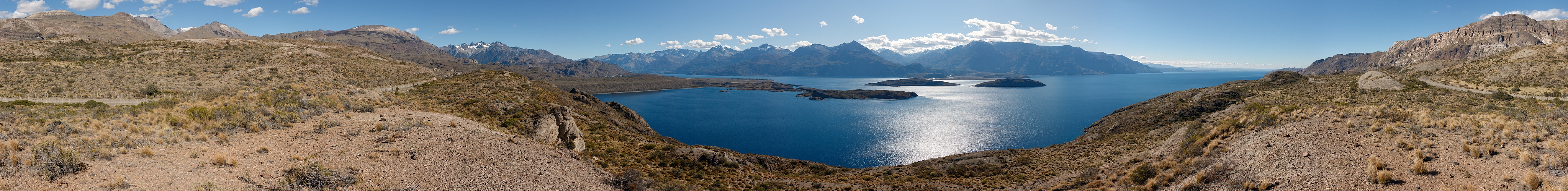
The road through Paso Las Llaves is a dreamy route or, at least, a scenic route that I undertook with a dreamy weather. It follows the whole southern side of the big Lago Carrera.
The kilometers from Cruce El Maitén, on the Carretera Austral, to Chile Chico, on the border with Argentina, are 124, all in ripio (gravel), mainly in bad condition. Few vehicles accept the challenge, and the touristic transit is substantially limited to two cases: 1) people following the Carretera Austral who want to have a detour to Chile Chico and Los Antiguos. From the latter site there are also one-day bus tours to the world-famous Cuevas de las Manos, a cave containing thousands of hands painted by the Tehuelches, and located not far from the likewise famous Ruta 40; 2) people following the legendary Ruta 40 and willing to dedicate a detour to the Capilla de Marmol, a marble cave on Lago Carrera accessible by boat from Puerto Río Tranquilo, which is not far from El Maitén. (Note that on Google Maps you find a... copy of the Capilla/Catedrál de Marmol also E of the islands in front of Fachinal. This is of course a misplaced object) So, to draw a tourist on this tricky crossing you seemingly need two ingredients, namely, a legendary road on one side on the Andes, and an attracting cave on the other side. This picture, however - as well as the preceding "It never rains in Patagonia" - is willing to demonstrate that the crossing would be interesting also on its own. On the 124 kms you find only two little bunches of houses, Mallín Grande and Fachinal, the latter with a little airport of the sort that you find nearly everywhere in the Aysén region. As for mountains, I am not able to single out a single summit with a name within these 360°. The low hills that you see far right are already in Argentina. To appreciate the geological feats about the lake, a reading of the material contained in N.19223 is recommended. 15 HF, Canon G1X, 43 mm, f/4.6, 1/800 sec. www.panoramio.com/photo/130332150 |
||||||||||||||||
|
|||||||


Comments
A clear explanation of the origin of the lake was once given on these pages by Matthias Stoffels, and is integrally reported in N.19223.
Substantially, the natural dam was once a glacier, barring the spot now known as "Desagüe del Lago Carrera", that is, the origin of Río Baker, which occurs in a very narrow spot.
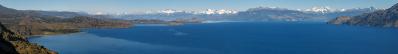
Perhaps this is better understood in a little panorama from the opposite shore:
www.panoramio.com/photo/127887899
Left, you see the arm depicted here, stretching into Argentina, and barred by a meseta of hills.
Right, by zooming you guess behind a little island the exact place where Río Baker originates.
Cheers, Alberto.
Leave a comment