|
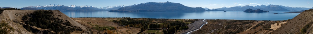
This pano it taken by the unsurfaced and adventurous - not to say how spectacular - road connecting the Carretera Austral to Chile Chico and its Argentinian twin site, namely Los Antiguos.
When I first published this pano, there were many more resources available in order to understand the geography of the region. Particularly instructive was the 360° from the 2027 m summit located at 271°, right in front of the San Valentín. Without these aids, I cannot but leave an in-depth explanation for the future. For now I simply paste, of the many comments which arose at the time, a very instructive one concerning the geology of the site.
In order to understand it, consider that hidden at the left end of the picture there is the "Desagüe del Lago Carrera", that is, the place where the water of the lake flows into Río Baker, the most voluminous river of Chilean Patagonia.
On the opposite side, short after the right end of the picture, the lake is delimited by a low meseta forming the watershed between Atlantic and Pacific.
Was wir hier sehen sind Deltaablagerungen. Das Top dieser Ablagerungen scheint dabei tatsächlich dem ehemaligen Niveau des Seespiegels zu entsprechen.
Die Absenkung des Seespiegels und nachfolgende erosive Freilegung der Deltasedimente ist eine Folge des Rückzugs der Gletscher nach der letzten Vereisung (vor rund 14 000 Jahren) als mehrfach eine stauende Eisbarriere am westl. Ende des Lago General Carrera brach und große Mengen Seewasser über den Rio Baker abfließen konnten.
Rechts kann man übrigens sehr gut erkennen wie sich erneut eine Deltafront in den See vorarbeitet.
Kind regards und herzliche Grüße, Matthias.
09.10.2014 00:00, Matthias Stoffels
Lago General Carrera is called also Lago Buenos Aires on the Argentinian side; the original Tehuelche name, however, was Lago Chelenko. As for extension, it ranks as the second lake in South America, after the Titicaca, and the mass of water that it contains is so impressive that it also affects the local climate. Los Antiguos is the site where the local Tehuelches carried the elderly people (antiguos) to spend their late age in a mild climate. Nowadays it is the location of the bid annual "Festival de la cereza" (cherry). On the other side of the border, the inhabitants of the tiny Chile Chico are particularly proud of their giant red apples, which are actually very tasty.
16 HF, Canon G1X, 89 mm equiv, f/5.6, 1/800 sec
www.panoramio.com/photo/128354632
GPS track: www.wikiloc.com/wikiloc/view.do?id=19531218
Klaus Brückner, Hans-Jörg Bäuerle, Friedemann Dittrich, Gerhard Eidenberger, Leonhard Huber, Thomas Janeck, Wilfried Malz, Giuseppe Marzulli, Steffen Minack, Jan Lindgaard Rasmussen, Danko Rihter, Arne Rönsch, Werner Schelberger, Björn Sothmann, Konrad Sus, Markus Ulmer, Jens Vischer, Matthias Weber
|
 |


Kommentare
Best, Alberto.
Kommentar schreiben