|
From Anopoli, 10 km after Hora Sfakion, a dirt road of 19.5 km length
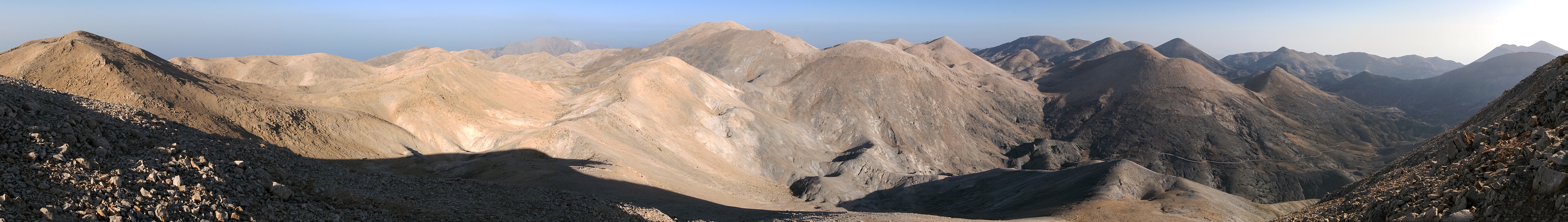
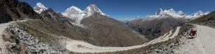
drives into the very heart of the Lefka Ori, a heart that the hundreds of tourists, descending everyday the Samaria gorge, hardly get to know, or even imagine. Actually, the name Lefka Ori, that is, «white mountains», is misleading, because at the end of the long trail one has tanked every sort of color. Even the road, snow-white in the first third, becomes red in the middle stretch, to end up dark in the enchanting Ammoutsera valley, surrounded by a crowd of conical peaks. Here, although the best shapes (culminating in the perfection of Grias Soros) are to be admired on the north, it is from the south side that the visitor's eye is caught by the powerful pyramid of Troharis, the second elevation of the range.
The nature of the massif, and the fact that it is virtually untrodden by trekkers (except for the E4 trail running a bit more on the north), makes the identification of the peaks very difficult. In order to label this pano I consulted a dozen of different sources - maps, books and web pages. Perhaps the sources are more than the names collected! As for names, the Udeuschle rendering is completely dumb. At the time of my travel the only source of web information was Summitpost, but now I realize that a remarkable deal of the data posted there are wrong. At present, the web page which appears to be more sound for topography is http://www.west-crete.com/pavlia-xalara.htm For example, the name of the Askifiotikos Soros, "unnamed on all maps" as noticed on the site itself, is drawn from there.
For the height of the peaks, the sources are more often than not in in disagreement. As an extreme case, the map published by Road Editions, which is very popular among tourists in Greece, reports a non-existent 2400-m peak north of the Troharis.
Although I have put some effort into the task of comparing the information critically, the resulting labeling is far from complete and/or reliable. Suggestions and corrections by experts are welcome.
Luckily, all sources agree at least on the name and height of the highest peak, the Pachnes, which with 2453m is by only 3m the second mountain of Crete. Michel Parmentier (Le grands raids à ski - Montagnes de la Méditerranée) reports about a huge 3m cairn having been erected on the summit by the Alpine Club of Chania to fill the gap with the 2456 m of the Psiloritis - the ancient Mount Ida, highest mountain of the island.
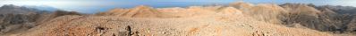
In 2008 however, while I found a nice chapel (equipped even with a cistern) on the top of Timios Stavros (=holy cross), culmination of the Psiloritis, there was only a little, cheap cross on the Pachnes. In spite of this, the aesthetic superiority of the Lefka Ori over the Psiloritis is undisputed.
An excellent reading for those interested in trekking on Crete is «The golden step» by Christopher Somerville, "trekking expert" of the Daily Telegraph. For his 50-th birthday he receives from his wife and employers an unusual present: two free months to realize the "dream of a life". And, for him, this dream takes the shape of a complete traverse of Crete, from the east end to the Hrisoskalitissas (=golden step) monastery on the opposite side. It is a pity for both the author and the reader that, due to the the abundance of snow, he has to skip the very heart of the Lefka Ori.
|
 |


Comments
Greetings HJ
Have fun,
Jochen
Leave a comment