|
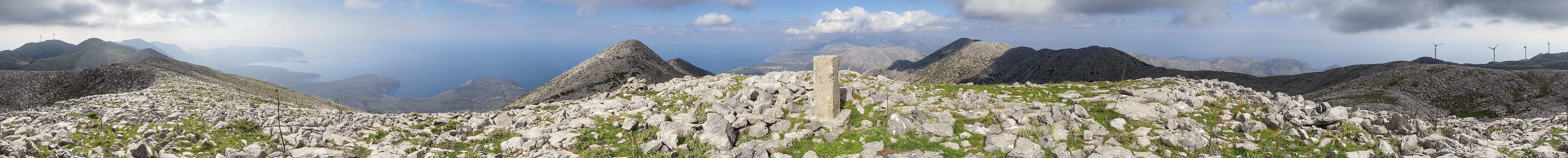
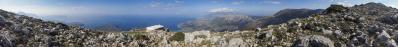
An der zuletzt gezeigten Profitis Ilias Kapelle endet zwar der Weg, aber ich hatte gelesen, daß man auf dem Rücken in Richtung Südosten noch auf den höchsten Punkt kommt. Es ging dort zweimal über die (auch hier sichtbaren) Erhebungen auf und ab und teils etwas mühsam durch Blockgelände. Statt des erwarteten Gipfels fand ich mich auf einer Art Hochebene mit dolinenartigen Senken. Immerhin aber ist dies der höchste Punkt der inneren Mani, des "Mittelfingers" der Peloponnes südlich der Straße Areopoli- Gythio. Von Osten ist die Erschließung mit Fahrwegen besser, vermutlich zum Betrieb der Windräder, die ich ich am Rand positioniert habe, um eine erneute Diskussion über dieses Thema zu vermeiden. Im Dunst sind der Lakonische und der Messenische Golf und auch die anderen beiden "Finger" sichtbar.
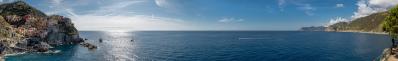
The path ends at the Profitis Ilias Chapel shown last, but I had read that you can still reach the highest point by walking along the ridge towards the south-east. There, I went up and down twice over the elevations (also visible here) and sometimes somewhat laboriously through blocky terrain. Instead of the expected summit, I found myself on a kind of plateau with doline-like depressions. Nevertheless, this is the highest point of the inner Mani, the "middle finger" of the Peloponnese south of the Areopoli-Gythio road. From the east, there is better access by dirt roads, presumably for the operation of the wind turbines, which I have positioned on the edge to avoid another discussion on this subject. In the haze, the Laconic and Messinian gulfs are visible, as are the other two "fingers".
Olympus OM-D E-M5 III
M.Zuiko 12-40/2.8 Pro @23mm (=46mm KB)
18 HF RAW freihand, ISO 200, 1/400, f10
Lightroom Classic CC, Autopano Giga 4.4.2, IrfanView
360° Blickwinkel
Direktlink auf Google Maps: https://goo.gl/maps/zRgC1qXrcR9dp5Vg7
Pedrotti Alberto, Hans-Jürgen Bayer, Peter Brandt, Jörg Braukmann, Hans-Jörg Bäuerle, Friedemann Dittrich, Wilfried Malz, Steffen Minack, Jörg Nitz, Jan Lindgaard Rasmussen, Björn Sothmann, Arjan Veldhuis, Jens Vischer, Augustin Werner
|
 |


Comments
Der Berg ist ja in etwa so hoch wie mein heimisches Mittelgebirge, aber eine völlig andere, karge Landschaft.
Leave a comment