
| Cycle through labels: |
|
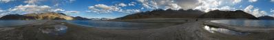
| Cerro Huarcopunta, 4761 |
| Cerro Pampacancha, 5006 |
| Hualcayan |
| Cordillera Negra |
| Cerro Cushuro, 5077 |
| Huaylas |
| Cerro Tres Cruces, 5147 |
| Punta Callhuash, 4708 |
| Abandoned houses |
| Cerro de la Colpa, 4053, 73 km |
| Canon del Pato |
| Ruinas de Auquispuquio |
| Wishcash |
| Quebrada de los Cedros |
| Nevado Champará, 5749 |
| Cerro Pakla, 4533 |
| 4660 |
| 5420 |
| Nevado Milluacocha, 5480 |
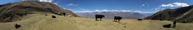
The Alpamayo trek is often done with start in Pomabamba, on the Conchucos (Amazonas) side of the Cordillera, and end in Hualcayán, on the Huaylas (Pacific) side. The passes to cross are Yanacon (4600), followed by the couple Mesapata (4450) and Gara-Gara (4830), and finally the couple Vientunan (4770) and Osoruri (4860). I had cloudy but acceptable weather on Yanacon and Mesapata, a sudden and violent snowfall on Gara-Gara, clouds on Vientunan and another stormy and windy snowfall on Osoruri.
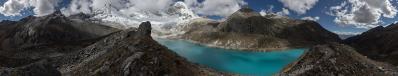
Besides the main trail, there are three classical side-trips: 1) to the Lagunas Safuna (Baja and Alta) plus Pucacocha/Llullacocha/Quitaracsa, 2) to the Santa Cruz Sanctuary, 3) to Laguna Yuraccocha. The first two were a fiasco as for the weather, and especially when I reached a highpoint at 5250 in the sanctuary I could have expected more than barely clouds. Thus, it was a welcome surprise when, with the bones still wet from the stormy Osoruri crossing, I found a welcome bivac site on one side of Laguna Cullicocha. The single bed in the free little building was perhaps intended for hosts of the care-takers of the dam, but I was actually very welcome, especially since with my portable solar panel plus power bank I was able to recharge the mobiles of the staff, which live otherwise completely severed from the outside world. "Where did your appliances take the energy", will the Betrachter ask after hearing the previous complaints about the weather. Of course, I am reporting the story very dramatically, being also accustomed to better weather, but of course I had also sunny moments, and sun is very powerful here, as you move constantly above 4000 m. Even better was the next morning when, following the wonderful path among granites and along the channel which provides irrigation to Hualcayán, I exited the troubled weather of the high Cordillera to enter the constantly blue sky of Huaylas. "But all my guidebooks say that good weather is guaranteed in the whole of the Cordillera", will the Betrachter complain this time. Yes, he is indeed right, the point is that even here climate change had major effects, such that the information contained in guidebooks, even in recent ones, has to be taken with plenty of care. Of my two panoramas N.26858 (Llanganuco in good weather) and N.26856 (Llanganuco in bad weather) the first one is indeed more pleasant, but the second one is by far more instructive, and does not need any comment. I tried to express in words the concepts expressed visually by this panorama to the people who were buying expensive package tours in a sunny Huaráz. They were almost certain to have a glorious summit ascent in their pocket... I warned them to no effect, they simply did not believe me, and indeed I did not insist, such that they could nourish the local economy and, at the same time, learn a bit of more humility for the next times - which thing is always useful. The first camping spot of the Alpamayo trail on the Huaylas side (so, the first for those coming from Hualcayán and the last for those coming from Pomabamba) is Wishcash, 4300 m, and I challenge everybody to find a more scenic place for their tent. But, while waiting for my night at Wishcash, I went for the third side-tour, the one to Laguna Yuraccocha. And here comes the present panorama. I had just wrapped most of my gear inside a black trash bag, hiding it behind a rock, which thing would not have been needed at all, since in the whole Alpamayo tour I met only three parties, none of them going for the side trips. The close little summit pointed by the path can be recognized close to the right border of N.26530. It is the last prominence of the ridge starting at the "inaccessible saddle" of N.26685. Much lower down, on a balcony at 3150 m, one sees the village of Hualcayán surrounded by reddish soil. Some rare species of vegetables are grown here, which are exported also to the USA. On the other side of the valley, on the NW flank of the Cordillera Negra, one sees the gravel road leading to the remote village of Huaylas, settled in a wonderful position, although it is partially hidden in the image by a minor ridge. Once it had a major importance, as is witnessed by the fact that it gives name to the whole Rio Santa valley, which is commonly called Callejón de Huaylas. Lower down, the Río Santa, coming from the open spaces of Huaraz, Yungay and Caraz, enters the narrow gorge known as Cañon del Pato, whose harshness can only be imagined in the present view. By means of the famous and spectacular 36 tunnels of the Cañon, one reaches the town of Huallanca where, at a more familiar elevation of 1450 m, the roads forks: left to the Ocean, which is reached at Chimbote, right (on very abandoned roads) to Pomabamba, around the northern corner of the Cordillera. Yuracmarca, the very first village above Huallanca, is visible on a sunny shoulder below Nevado Champará. From the Huaylas side I returned - always by foot - to the Conchucos side along the classical Santa Cruz trek. At Pomabamba, where I had left the bicycle in my hostel for two weeks, I was supposed to complete the whole loop around the Cordillera cycling also the northern end, but the weather was getting more and more unstable on the Conchucos. This, together with rumours of possible robberies in the very isolated places north of Poma, gave me the inspiration to leave in peace these least few kms, and to head instead south to the Cordillera Huayhuash, where the weather turned out to be astonishingly different. After Huayhuash, I returned to the Cordillera to cycle the Olimpica (4890) - Llanganuco (4767) loop, thus bringing to six the number of crossings of the Cordillera Blanca, four by bicycle and two by foot. Back to the Huaylas side, I was left only with two days. A first choice would have been a stroll from Caraz to Laguna Parón, from 2200 to 4200 m all on gravel, but I thought that I had enough of the dust produced by tourist taxis (back from the Llanganuco I was barely able to speak). On the opposite side, I had the chance of a ride to Chicarhuapunta, 2200 m to 4400 on asphalt in the Cordillera Negra, but I had already done something similar at the very beginning Callán Punta (for now I published only N.26074). So, I opted for the unknown: I thought of the wonderful road to Huaylas that I had admired for so long from Wishcash. Not even 3000 m as for elevation, but very tough as for road condition. In the wonderfully sleepy Huaylas I lingered a couple of hours listening to a parade of musical bands (in Perú it is everywhere more common to find some feast than not to find it...). My proposal was to let the time pass: namely, the information coming from the maps was that a wonderful asphalted road awaited me, leading from Huaylas down to Huallanca, 1400 m lower down, through a sequence of panoramic switchbacks. The plan was then for the following day - the last one before dismounting the bicycle - to cycle upwards the Cañon del Pato, thus closing yet another valuable loop in Ancash. But not all things go smoothly... When I asked in town for the start of that wonder (I did not see any asphalt all around) the answer was: it is better for you to go back through the same road, which is in so good conditions (!!), because the other is truly terrible, and the locals rarely fight with it. So I found myself cycling back the gravel road at evening, and then strolling down the 36 tunnels of the Cañon del Pato at night - which thing was indeed pictoresque, but I think also an unprecedented experience for a foreign cyclist, as I understood from the wonder that my late coming caused in Huallanca. The next day, after cycling up the 36 tunnels, I was left with one last research to do. Marked in the panorama is the hill hosting, in wonderful and superb isolation, the ruins of Auquispuquio, a sort of Machu Picchu of the Cordillera Blanca. It is not as hight as Yayno (N.26108), but the access to Yayno is a joke in the comparison. The Alpenvereinskarte marks a path ascending from the Cañon (here approx. 1800 m) to Auquispuquio (3800 m), all along the exposed ridge. I think that this ascent should be an incredible experience, but I was not able to understand even how to start it! namely, all the bridges over the canyon belong to hydroelectric plantations and are closed by high gates. There should be, however, an alternative access to Auquispuquio... An evident path connects the village of Alpamayo and the remote settlement of Quitaracsa through the saddle at 4640 m which I marked in the panorama. On visible meadows of the S side, a very faint and partly disappeared path forks to Auquispuquio, which is thus reached from above via a steep final stretch (which can be guessed also at 500 pixel) which, as local guides told me, is "potentially dangerous". In any case, having to survive from Pomabamba to Hualcayán, without guides and mules, I could not afford to use additional days for extra research. So, the mysterious and nearly unreachable Auquispuquio has become for me the nicest "unsolved problem" in these surroundings. What I did not leave as an unsolved problem was a visit to what i marked as "Abandoned houses": a viewpoint with an incredible Tiefblick over the Quebrada de los Cedros, with Auquispuquio right in front, and at a comparable elevation - you can imagine to reach it with a single jump... Remarkable is what the villagers of Alpamayo are able to do with their mules. They start from 3900, cross Vientunan and Osoruri (which are close passes, but by no means a single pass), descend to Cullicocha and Wishcash, reaching Hualcayán at evening. The next day, loaded with provisions, they go back to their village, thus walking in a single day what takes at least two days to every guided party. And - I meet a caravan of them while approaching the Vientunan - they are not young at all! Why they still live there, at the end of the inaccessible gorge "Quebrada de los Cedros", now that the once cultivated terraces are virtually abandoned, is not clear, but I heard rumours that they are taking care of some gold mines in the vicinity. Location: -8.87725 -77.77423 Larger: https://bit.ly/39wpD3j |
||||||||||||||||
|
|||||||


Comments
Danke, dass du diese Eindrücke mit uns teilst.
Leave a comment