
| Cycle through labels: |
|
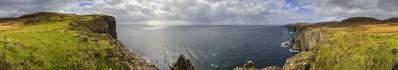
| Vardousia - Korakas (2495m) |
| Vardousia - P.2413 |
| Vardousia - Chomiriani (2294m) |
| Pirghos (2151m) |
|
||||||||||||||||||||||||||
Nach der Vorfrühstücks-Vorfreude (#26419) kam das Frühstück, bei dem - wie öfters - eine griechische Wirtin Ihre Angst vor meinem Verhungern erfolgreich bekämpfte. Hier noch ein Tyropita und da noch zwei Stück Kuchen, und ein Ei geht gar nicht allein...die Engländer und Schotten können da fast nicht mehr mithalten.
So für den ganzen Tag gestärkt, setzte ich mich für die kurze Strecke ins Dorf Athanasios Diakos (umbenannt nach einem Freiheitskämpfer des 19. Jahrhunderts) ins Auto und lief dort auf etwa 1000m los. Es geht zunächst auf dem Fernwanderweg E4, dessen Markierung nur am Ortsrand etwas unklar war, steil durch den Wald hinauf. Der Normalweg auf den Korakas, den höchsten Gipfel der Vardousia, führt über eine Hochebene mit Almen, Fahrwegen und zwei griechischen Alpenvereinshütten und dann von Westen auf den Gipfel. Ich hatte alternativ einen Anstieg von Norden erkundet und fand mich bald auf schöner Wegspur. Eine Felsbarriere wird ganz links leicht in einer Rinne überwunden, dann eröffnet sich der hier gezeigte Rundblick in die einsame Bergwelt und zum Gipfel. Weglos, aber ohne Orientierungsprobleme ging es weiter bergauf. ======================================== After the pre-breakfast anticipation (#26419) came the breakfast, at which - as often - a Greek landlady successfully fought her fear of my starvation. Yet another Tyropita and two more pieces of cake, and an egg does not go at all alone...the English and Scots are struggling keep up. Thus strengthened for the whole day, I went for the short distance to the Athanasios Diakos village (renamed after a freedom fighter of the 19th century) in the car and started there on about 1000m. The ascent starts on the long-distance trail E4, whose marking was somewhat unclear only at the edge of the village, and rises steeply up through the forest. The normal route to the Korakas, the highest peak of the Vardousia, leads over a plateau with alpine pastures, driveways and two Greek alpine club huts and then from the west to the summit. I had alternatively explored an ascent from the north and soon found myself on a nice trail. A rock barrier is easily overcome on the very left, then the panorama shown here opens up into the lonely mountain world and to the summit. Pathless but without any orientation problems, I continued uphill. ======================================== Olympus OM-D E-M10 M.Zuiko 14-42 EZ @14mm (=28mm KB) 23 HF RAW freihand, ISO 200, 1/400, f10 Lightroom Classic CC, Autopano Giga 4.4.2, IrfanView 360° Blickwinkel Direktlink auf Google Maps: https://goo.gl/maps/7MRWK3GMyd7Xtj9w7 |
||||||||||||||||
|
|||||||


Comments
Wenn dies ein Rätsel gewesen wäre, hätte ich Griechenland definitiv nicht als erste Wahl in Erwägung gezogen.
VG Werner
Herzliche Grüße
Hans-Jörg
Leave a comment